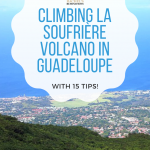
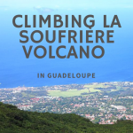
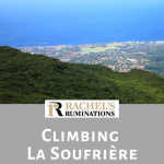
La Soufrière Volcano hike in Guadeloupe
As you might have guessed from my description of walking to Le Carbet waterfall #2, I’m not much for walking or hiking. It’s not that I don’t enjoy a pretty view or like to catch sight of a colorful bird or picturesque waterfall. I do. It’s just that I’m terribly out of shape, and that’s because I’m just plain lazy. Most of the time I just can’t be bothered to go walking.
Except when I travel, that is. Then I want to see everything, and I’m perfectly willing to do whatever walking is necessary to achieve that.
Disclosure: This post contains affiliate links. That means I’ll receive a small commission on anything you buy through clicking the links. This will not affect your price.
[Voor Nederlands vertaling, zie beneden.]

A Guadeloupe volcano
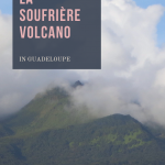
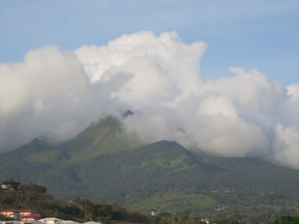
La Soufrière volcano forms the centerpiece of the western “wing” of Guadeloupe (Guadeloupe’s main two islands form the shape of a butterfly.), and the focal point of the Parc Nationale de la Guadeloupe (National Park of Guadeloupe). It last erupted in 1976. The last earthquake, also associated with the volcano, was in 2004. In other words, it’s still active.
Nevertheless, visitors can walk all the way to the top. It’s a longer walk than before 2004’s earthquake, which damaged the last bit of the road up the volcano. Now, you first drive to a parking area below the volcano, called Les Bains Jaunes (950 meters elevation), walk up to the old parking area, called Savane à Mulets (1142 meters) and then start the climb up the volcano to the peak at 1467 meters.
In planning my visit to Guadeloupe, it became clear from my reading that I should hike La Soufrière volcano, and I’m proud to say I made it all the way to the top.
To read about all the best things to do in Guadeloupe, see my guide to Guadeloupe!
Three parts of the path
I experienced the three parts to the path very differently:
Part one of the La Soufrière volcano hike
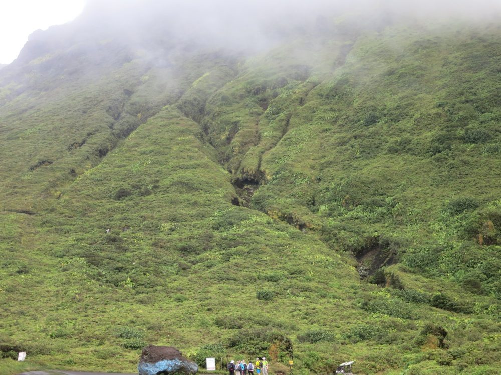
The first walk, between the first and the second parking areas, is rated as facile: easy. And it is, relatively speaking. The trail is well maintained and rises steadily but not steeply. It winds through rainforest, and I noticed how the vegetation changed as I went up: the trees were very tall at Les Bains Jaunes, but gradually reduced in height and girth with increasing elevation. I think that change isn’t just about elevation, but also about the amounts of wind and rain up there.
Right away, I was huffing and puffing. I’m not in condition for walking steadily uphill. At this point I didn’t find it a problem, though. I was alone and had left Les Bains Jaunes at 9:30, so I had all day if necessary. Whenever I was out of breath, I stopped.
Arriving at the old parking area was a bit of a surprise. Suddenly, the trees just stop and there is only low, bushy growth. Apparently this area was all burned in the 1976 eruption. Seeing the scene and reading that information really brought home to me that this was a live volcano I was climbing!
Part two of climbing La Soufriere volcano
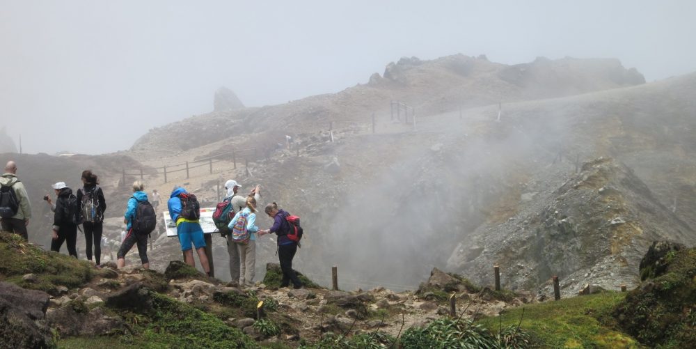
The second part, most of the way up the volcano, is rated difficile: difficult. The trail is steeper and gets less and less well-maintained. I had to watch every step, since the trail was alternately rocky and muddy, and I often found myself planning several steps ahead.
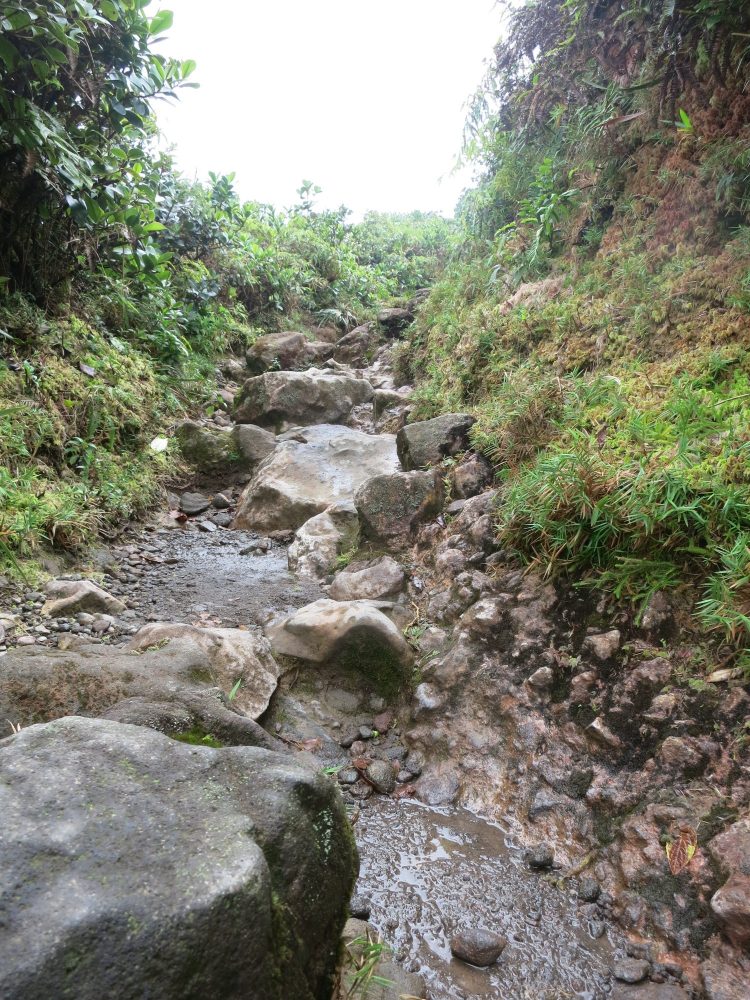
I stopped a lot too because I kept losing my breath. Since I had to watch my step so much, it was good to stop anyway; it allowed me to admire the views.
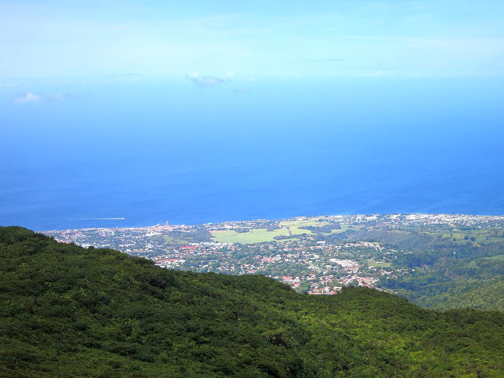
Speaking of the views, they changed rapidly. I was at cloud level by this time, so sometimes I was socked in, but the clouds moved very quickly in the strong breeze and it could be a matter of seconds before the whole view opened up again.
Part three of my La Soufrière volcano hike
The last part is also rated as difficult. It’s quite short—perhaps ten to fifteen minutes—but this part involves actual climbing. It’s not bad enough to need ropes, but I had to use my hands as well as my feet to scramble up the rocks. The wind up there was very strong as well, which didn’t help matters. I tried not to think about what would happen if I injured myself in such an awkward spot…
Knowing that I was almost there was what stopped me from giving up and turning back at this point. I was exhausted and regretting the whole thing, but determined to finish what I’d started. The air, by the way, had started to smell like sulphur, the odor of the gas escaping in several parts of the cone.
All told, the climb took me about two and a half hours going up. The signs at Les Bains Jaunes had indicated one hour and forty-five minutes. My slow ascent mostly had to do with my stopping to catch my breath or drink water.
At the top of La Soufrière
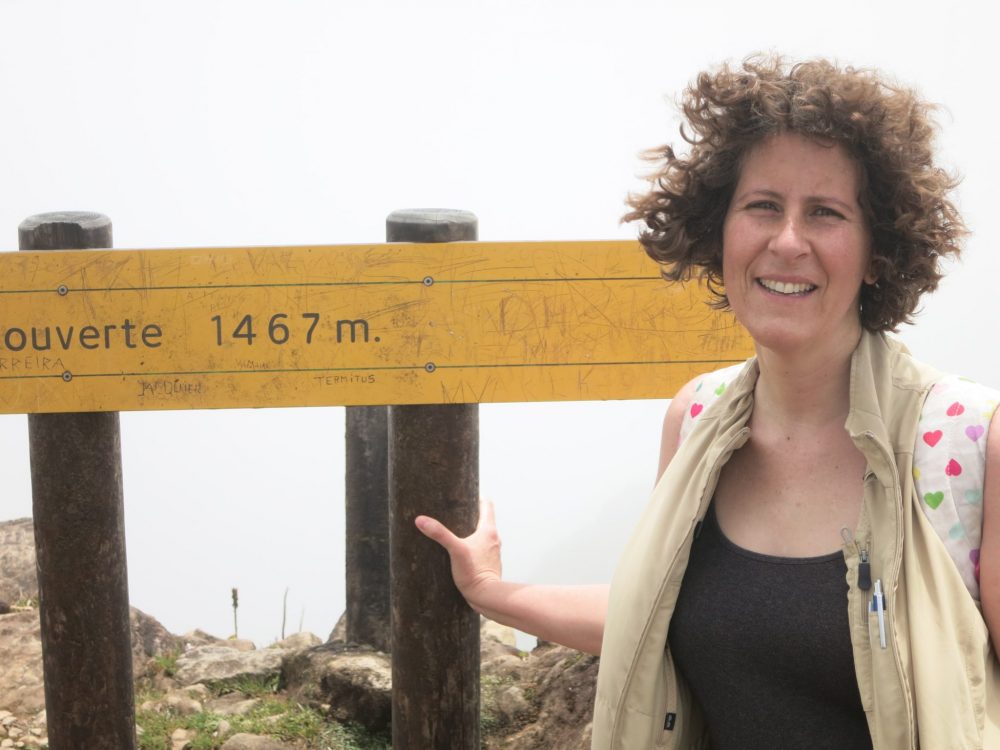
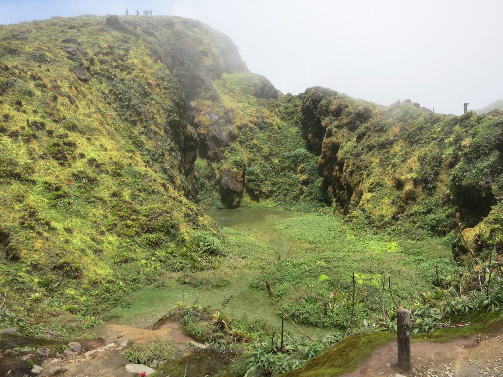
At the top it was incredibly windy. After the obligatory photo op at the elevation sign, I started down into the crater. There are trails around the edge too, but the wind was too much, in my rather nervous state once I was up there, for me to want to stay on the edge. There wasn’t much of a view other than down into the crater anyway: too much cloud.
In the crater, the cloud lifted enough for me to see La Porte de l’Enfer, or Hell’s Gate. Or, at least, I could see that there was a big, wide crevice and lots of sulphur-smelling smoke coming out of it. Opposite it, and also in the cone, was a small and very green valley. I suppose it formed in the last eruption, but because there’s no gas leaking at that spot, the vegetation has been able to grow back.
As I stood on the raised path between the two, within meters of both, conscious that I was standing in the middle of an active volcanic crater, I felt very uneasy, as you can imagine.
A few steps down the trail was a vent emitting smoke and making a strange sound. It was fenced off because, according to the warning signs, it produces toxic gases. Unfortunately, the wind noise in the video below masks the sound the vent was making. It resembled the sound of a car passing at high speed.
The descent
I’m not sure which was harder: climbing up or climbing down. On the way down I didn’t get out of breath, but I was so tired from the climb up that my legs felt like rubber. When I’m that tired, I tend not to lift my feet as much, and I stumble. Up there on the mountain, I stumbled a lot.
I was well aware that I could really hurt myself by twisting an ankle or by falling, so I had to make the effort to walk/climb slowly and be aware of where I planted my feet. I wasn’t too worried, though, in that there were other people working their way either up or down, so I wasn’t entirely alone. If I needed it, I could get help.
I did, however, manage to twist both ankles. Fortunately, they were both the kind of ankle injury that hurts as you’re doing it, but fades right away. I could “walk them off,” in other words.
It took me about an hour and 45 minutes to reach the bottom. It should have taken an hour. My thighs hurt for days afterwards.
My advice for your La Soufrière volcano hike in Guadeloupe
- Be fitter than I am, or leave plenty of time.
- Wear stout shoes! Preferably with ankle support. And good traction.
- Bring a windbreaker. I had a sweatshirt with me, which I needed at the top in the wind. A windbreaker would have been better. You might get rained on as you go, but I didn’t mind that, since I was sweating so much.
- Don’t bother with a hat. It won’t stay on.
- Put on sun lotion before you set off. You won’t get much sun, but it does peek through now and then, and you can get burnt through clouds anyway.
- Water: bring lots of it. I went through two liters on the climb up and down.
- Food: you’ll need snacks to keep up energy along the way.
- Carry a backpack for your water and food. You’ll need both hands free to grab for support as you go.
- Watch your step. If you want to look at the view, do it after stopping!
- Do stop and look at the view. It changes by the minute.
- Give yourself enough time so that you can be all the way down before dark. Sunset happens fast in Guadeloupe!
- Walk slowly coming down.
- No facilities are available at all, not even at the start of the Guadeloupe volcano’s trail. If you need to pee, you’ll have to find somewhere to leave the path, and that would be hard after the old parking lot.
- Don’t bring small children. Some parents were really struggling to keep their smaller children safe. Nothing is there to stop them from falling and hurting themselves in pretty gruesome ways. I wouldn’t do this climb with a kid younger than about eight: one who does what he or she is told!
- Say bonjour to everyone you pass. It seems to be expected.
Getting to La Soufrière volcano
La Soufriere is on the western half of the island, and the access road (the D11) can be reached from the small town of Saint-Claude in the southwest. You can park for free at the end of the road at Bains-Jaunes to start your walk. (If you’ve signed up for any of the tours above, they’ll give you a meeting point.) There is no fee to climb the mountain.
If you like this article, you might also enjoy these other articles about Guadeloupe:
Please share the pin below!
La Soufrière vulkaan beklimmen
Zoals je misschien van mijn beschrijving van de tocht naar de 2e waterval van Le Carbet, al kon raden, ben ik geen fan van wandelen. Ik geniet wel van een mooi uitzicht, een mooie vogel of een waterval zien. Ik heb mijn conditie totaal niet op peil en dat komt omdat ik gewoon lui ben. Ik heb er gewoon geen zin in.
Althans, als ik op reis ben heb ik dat wel. Dan wil ik echt alles zien en ben ik volkomen bereid om te wandelen om dat doel te bereiken.
De vulkaan La Soufrière vormt het middelpunt van de westerlijke ‘vleugel’ van Guadeloupe (De twee belangrijkste eilanden van Guadeloupe hebben de vorm van een vlinder.). De laatste uitbarsting was in 1976. De laatste aardbeving, ook in verband met de vulkaan, was in 2004. Met andere woorden, hij is nog steeds actief.
Toch kunnen bezoekers de hele weg naar de top lopen. Het is een langere wandeling dan vóór de aardbeving van 2004, die het laatste stukje van de weg tot de vulkaan beschadigde. Nu moet je eerst naar een parkeerplaats bij de voet van de vulkaan rijden, die heet Les Bains Jaunes (950 meter hoogte), dan loop je naar het oude parkeerterrein, Savane à Mulets (1142 meter) en dan begin je met de beklimming van de vulkaan naar de top van 1467 meter.
Toen ik mijn bezoek voorbereidde aan Guadeloupe, werd duidelijk dat ik de vulkaan La Soufrière moest gaan klimmen en ik ben trots om te zeggen dat ik de top heb bereikt.
Ik ervoer de drie delen van de weg heel anders:
Deel één van het beklimmen van de La Soufrière
Het eerste pad, tussen de eerste en de tweede parkeerplaatsen, wordt beoordeeld als facile: eenvoudig. En dat is waar, relatief gezien. Het pad is goed onderhouden en stijgt gestaag, maar niet steil. Het slingert zich door het regenwoud en ik merkte hoe de begroeiing veranderde langs de route: de bomen waren erg lang bij Les Bains Jaunes, maar geleidelijk verminderden deze in lengte en breedte en nam de hoogte toe. Ik denk dat de verandering niet alleen door de hoogte werd veroorzaakt, maar ook over de hoeveelheid wind en regen.
Meteen begon ik te puffen en te hijgen. Ik heb de conditie niet om gestaag bergopwaarts te wandelen. Ik vond het toch geen probleem. Ik was alleen en vertrok uit Les Bains Jaunes om 9:30, ik had dus de hele dag als het nodig zou zijn. Elke keer als ik buiten adem raakte, nam ik pauze.
Toen ik aankwam bij de oude parkeerplaats was ik een beetje verrast. Plotseling houden de bomen gewoon op en er is slechts lage, struikachtige groei. Blijkbaar is dit gebied allemaal verbrand in de uitbarsting van 1976. Door het zien van dit beeld en door die informatie die ik gelezen had begreep ik dat deze vulkaan nog volop actief was!
Deel twee van het beklimmen van de La Soufrière
Het tweede deel, het grootste deel van de weg naar boven, heeft als beoordeling difficile: moeilijk. Het pad is steiler en wordt hoe hoger, hoe minder goed onderhouden. Ik moest elke stap goed uitkijken, omdat het parcours afwisselend rotsachtig en modderig was. Daardoor moest ik mijn stappen steeds goed vooruit plannen zodat ik ze juist neerzette.
Ik nam ook vaker pauze omdat ik eerder buiten adem raakte. Doordat ik telkens naar de grond moest kijken en goed moest opletten, was het ook fijn om even te stoppen. Ik kon dan ook van het uitzicht genieten.
Als we het dan over het uitzicht hebben, dit veranderde heel snel. Ik liep tussen de wolken en kon dus soms heel weinig zien, maar de wolken verplaatsten zich zeer snel in de sterke wind en het kon een kwestie van seconden zijn voordat het hele uitzicht zich opnieuw openbaarde aan mij.
Deel drie van de tocht op La Soufrière
Het laatste deel is ook beoordeeld als moeilijk. Het is vrij kort, misschien tien tot vijftien minuten, maar dit deel vergt het daadwerkelijke klimmen. Het is niet slecht genoeg om touwen nodig te hebben, maar ik moest mijn handen evenals mijn voeten gebruiken om te klauteren op de rotsen. Op die hoogte stond ook een behoorlijke wind, hier werd het uiteraard niet makkelijker door. Ik probeerde niet te denken over wat er zou gebeuren als ik verwond zou raken op zo’n lastige plek…
Wetende dat ik er bijna was weerhield me om op dit punt op te geven en om te draaien. Ik was uitgeput en betreurde het hele onderneming, maar ik was vastbesloten om, wat ik was begonnen, af te maken. Trouwens, op dit punt begon de lucht te ruiken naar zwavel, de geur van het gas die ontsnapt in verschillende delen van de conus.
In totaal kostte de klim me ongeveer twee en een half uur om boven te komen. De borden bij Les Bains Jaunes hadden een uur en vijfenveertig minuten aangegeven. Mijn langzame klim had vooral te maken met het stoppen om op adem te komen of om water te drinken.
Aangekomen
Op de top stond er ongelooflijk veel wind. Na de gebruikelijke foto voor de bord met de hoogte, begon ik de krater in te lopen. Er zijn paden rond de rand van de krater, maar de wind was te fel om in mijn, nogal nerveuze toestand daar op die rand te willen blijven. Er was toch geen uitzicht door de vele wolken waarin wij ons bevonden, behalve het zicht naar beneden de krater in.
In de krater, de wolken waren net hoog genoeg zodat ik La Porte de l’Enfer, of Hellespoort, kon zien. Althans, ik kon zien dat er een grote, brede spleet was waaruit veel rook kwam. Er tegenover, ook in de krater, was een kleine en zeer groene vallei. Ik veronderstel dat het veroorzaakt werd door de laatste uitbarsting, maar omdat er geen gas lekte op die plek, kon er weer vegetatie groeien. Ik voelde me erg ongemakkelijk om, precies tussen de twee zijkraters en enkele meters van beide, in het midden van een krater te staan!
Er was ook een stoomgat dat een vreemd geluid maakte. Het was omheind omdat het, volgens de waarschuwingsborden, giftige gassen produceert. Helaas maskeert het suizen van de wind in de video hieronder het geluid van het stoomgat. Het leek op het geluid van een passerende auto met hoge snelheid.
De afdaling
Ik weet niet zeker wat ik moeilijker vond: het opklimmen of afdalen. De weg naar beneden raakte ik niet buiten adem, maar ik was zo moe van de klim dat mijn benen voelde als rubber. Als ik zo moe ben, heb ik de neiging om mijn voeten niet genoeg op te tillen en struikel ik. Daarboven op de berg, struikelde ik veel.
Ik was me er goed van bewust dat ik mij echt pijn kon doen door bijvoorbeeld het verdraaien van een enkel of door te vallen, dus moest ik voorzichtig gaan lopen en er bewust van blijven waar ik mijn voeten neerzette. Ik was niet al te bezorgd omdat er toch ook andere mensen waren die omhoog of omlaag liepen, dus was ik niet helemaal alleen. Als ik het nodig had, kon ik hulp krijgen.
Ik kreeg het toch voor elkaar om beide enkels te verzwikken. Gelukkig waren ze van het soort enkelblessure die pijn doet op het moment dat je de enkel verzwikt, maar daarna gelijk verdwijnt. Ik kon gelukkig de pijn eruit lopen.
Het kostte me ongeveer een uur en 45 minuten om beneden te komen. Het zou een uur duren, volgens de borden. Ik had nog dagenlang last van mijn dijen.
Mijn advies voor het beklimmen van La Soufrière vulkaan:
- Wees fitter dan ik ben, of neem genoeg tijd.
- Draag stevige schoenen! Bij voorkeur halfhoog; met enkel ondersteuning. En een goede grip.
- Breng een windjack. Ik had een trui bij mij, die ik bovenop nodig had in de wind. Een windjack zou beter zijn geweest. Het zou ook kunnen regenen, maar dat vond dat niet erg, omdat ik zo veel zweette.
- Neem geen hoed mee. Daarvoor waait het te hard.
- Doe zonnecreme op voordat start. Je krijgt niet veel zon, maar de zon gluurt af en toe door de wolken, je kunt verbranden ook als de zon achter de wolken zit.
- Water: neem veel mee. Ik dronk twee liter op de klim.
- Eten: snacks eten onderweg geeft energie.
- Draag een rugzak voor uw water en voedsel. U zult beide handen nodig hebben bij het klimmen en klauteren.
- Let op waar u loopt. Als je wilt kijken naar het uitzicht, stop dan even met lopen!
- Stop regelmatig om te kijken naar het uitzicht. Het verandert per minuut.
- Geef jezelf genoeg tijd, zodat je terug bent voordat het donker wordt. De zonsondergang in Guadeloupe gaat snel.
- Loop langzaam naar beneden.
- Er zijn geen faciliteiten beschikbaar, zelfs niet bij het begin van het pad. Als je moet plassen, moet je ergens een plek vinden om de weg te verlaten en dat is moeilijk na de oude parkeerplaats.
- Neem geen kleine kinderen mee. Sommige ouders hadden echt moeite om hun kleine kinderen veilig te houden. Er is nergens een hek geplaatst. Ze kunnen zichzelf verwonden op een gruwelijk manier. Ik zou deze tocht niet doen met een kind jonger dan acht: een kind die doet wat hij of zij wordt verteld!
- Zeg ‘Bonjour‘ naar iedereen die je passeert. Het lijkt verwacht.

Rachel Heller is a writer living in Groningen, the Netherlands. She is the owner and primary author of this website, Rachel’s Ruminations, a travel blog focused on independent travel with an emphasis on cultural and historical sites/sights. Read more here about her and about this website. All photos in her articles are her own, unless otherwise specified. Rachel also owns and operates a website about World Heritage travel.
I heard about La Soufriere Volcano 25 years ago and your post brought it to life. The hike did not look easy but I congratulate you for completing it. The views were amazing but too bad it was so cloudy at the top.
It wasn’t cloudy the whole time; it changed by the minute. But I didn’t want to keep asking random strangers to take my picture!
How long did it take to hike to the top?
Two and half hours to go up, and a bit under two hours to get down again. But people who are in better shape than I am/was, can do it faster.
Did you find it was an okay hike without a tour guide or do you with you had one?
I did it without a tour guide. I think for someone in better shape than I am it would be a fairly simple hike. As you can read in the article, I was huffing and puffing and ended up injuring my ankles. A tour guide wouldn’t have been able to help with that, but he/she would have made me feel a bit less alone.
Perfect! Thank you! Additionally, I’ve seen some tours for sunrise hikes with guides, do you think that’s a feasible hike to do without a tour guide @ 4am?
Also, would you day that the roads to the trailhead are well maintained? I saw it said to be wary when driving on those roads.
I bet a sunrise hike would be gorgeous! If you’re contemplating it, you must be an experienced hiker. I think it would be feasible, but not solo, and only with a good bright lantern: the kind you wear on your head so your hands are free. That last section, which is really climbing, would be risky in the dark — I thought it was risky in daylight! The road up there is narrow with sharp curves, but my little rental could manage it just fine.
Okay! Would you say those barrow and sharp curves may be dangerous in the dark, if we were to drive at 4am for the morning hike? Thank you so much! You’ve been an immense help!
No, I don’t think so. I assume your car will have headlights and you won’t drive too fast! 😉 Anyway, you can only drive as far as les Bains Jaunes, unless they’ve opened the next section up to Savane a Mulets since I was there.
Going to do the hike in a week. What a great overview and tips!
I’d love to hear your report on if anything has changed since I did it. It would help me update this article!