3-week Iceland itinerary: the best Iceland road trip!
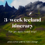
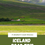
Three weeks is about the perfect length of time for an Iceland road trip in the summer. My husband and I had three weeks free and drove right around the country to see pretty much all the highlights.
What follows here is a three-week Iceland itinerary. It’s a bit different from what we actually did; I’ve adjusted it to eliminate some backtracking and to allow the right amount of time for each place. I’ve described what we did and saw, and in some places I’ve added other options you could do that we didn’t do.
[Thoroughly updated January 2026.]
Disclosure: This article contains affiliate links. Making a purchase through an affiliate link will mean a small commission for this website. This will not affect your price. Privacy policy.
Subscribe to my newsletter to get a much shorter version of this 3-week Iceland itinerary: a downloadable, printable, pdf version, pared down to just the most necessary information, last updated in December 2025. Don’t worry; I’ll never share your email with anyone!
About driving in Iceland
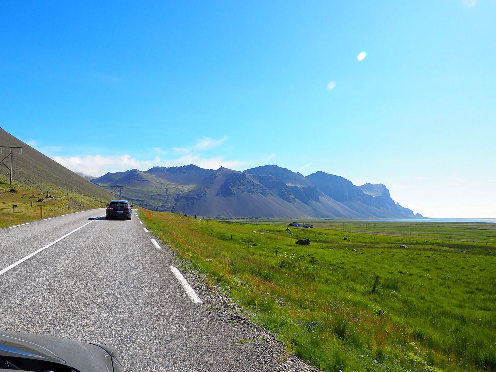
We rented a car for the whole three-week trip, picking it up at the airport on arrival. We chose a small two-wheel-drive car because it was summertime, and we only planned to do the ring road around the country anyway. A two-wheel-drive would also work for late spring and early fall. However, you’ll need to rent a four-wheel-drive car if there’s any chance of temperatures dipping below freezing, and also if you ever want to drive on an unpaved road (F-road).
Never stop on the road, even when there’s no one else in sight. Wait for a place where you can pull off the road entirely. Open your car door carefully; the wind can be very strong in Iceland and can actually break the door. Think about getting the full insurance coverage on your rental so you don’t get charged for damage to the undercarriage when you pull off the road or for damage to the car.
About the maps
At the bottom of this article is an Iceland trip map. I’ve placed every sight listed in this article on that map.
To help you find accommodations, I’ve added links and/or a map for each of the locations where I recommend that you stay. The maps are clickable to book accommodations.
I’ve also added some of the accommodations we stayed in, but only the ones that turned out to be in good locations. Every accommodation was clean and at least adequate to our needs or better. Please note, however, that in most places there are plenty of options of places to stay. Either use the more specific location maps, or you can use the map below to book your accommodations. It doesn’t show anything until you zoom into the area where you want to stay.
If you’d rather see the whole 3-week Iceland itinerary at once, just look at the table of contents below. You can click on any part of the itinerary to jump to that part.
I should also note that it is very unlikely you could visit every place listed below in three weeks. If you have, I’d say, about five weeks, then you probably could. You’ll have to make some choices as you plan your trip.
Day 0: Arrival at Reykjavik
Chances are you’ll be tired from traveling, so the first thing to do is get to your accommodations.
Accommodation for 2 nights: Reykjavik
In Reykjavik, we stayed pretty far out of the city. You might prefer to book something closer in to the center.
Book accommodations in Reykjavik by clicking on the map below:
Day 1: Reykjavik
Stay two nights and one full day in Reykjavik now, at the beginning of the trip, but then at the end of the trip you’ll have time to see more. Here is a list of all the sights you could choose from. For the ones we visited, you’ll see a more detailed description than the ones we didn’t see.
I’d strongly suggest starting with a walking tour and/or visiting the National Museum, to get the background that will help you understand what you see throughout the trip. The rest of the Reykjavik sights I’ve listed below in alphabetical order.
“Free” walking tour of Reykjavik by City Walk
I highly recommend taking a walking tour when you first arrive in any new city or country. It helps give you the general overview in terms of history as well as an idea of the layout of the most visit-worthy parts of the city. We took a “free” walking tour organized by City Walk and were glad we did. You can read my review of the walking tour here.
The gimmick with a “free” walking tour like City Walk is the expectation that you will give a good tip to pay the guide. There are plenty of other tours available in Reykjavik: short tours, whole day tours, theme tours of various sorts (food, drink, elves and trolls, whales, etc.). Here is a link to a bunch of them.
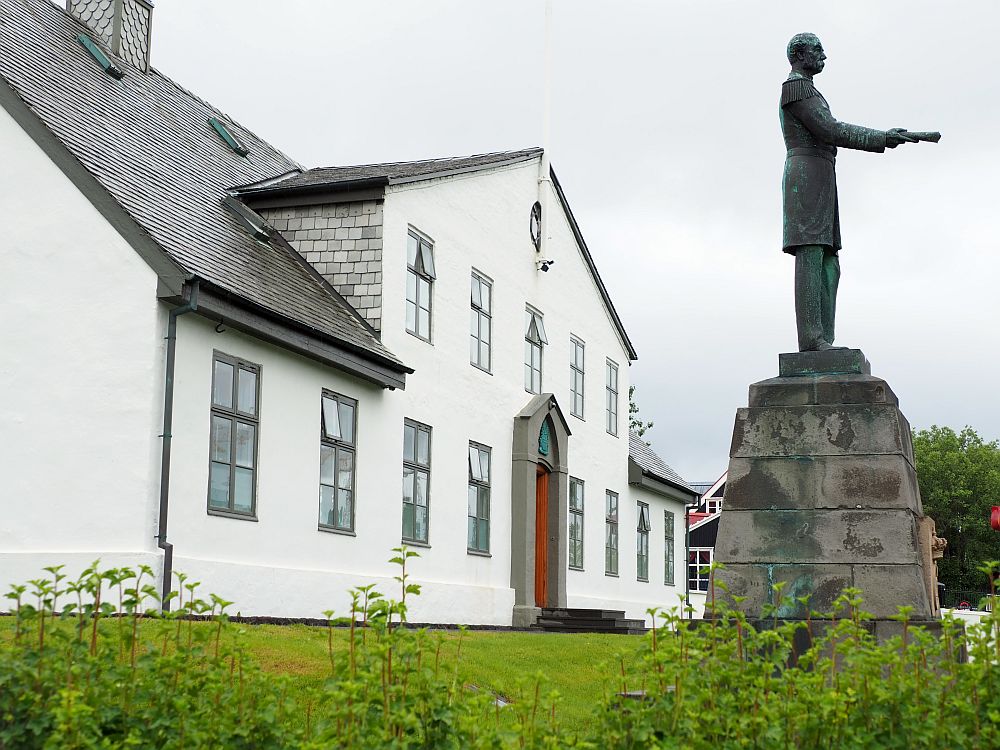
The National Museum of Iceland
This excellent museum is also a good thing to start with on arrival in Iceland. Objects from Iceland’s history are displayed chronologically, from the first settlers in the 9th century to the present day. Sometimes, within that chronology, displays are grouped by topic.
Often this is the usual items-in-cases style, but broken up here and there with interactive elements, such as videos that allow visitors to choose directions, and audios that are fictionalized versions of daily life.

What struck me about Iceland’s story as I saw it in this museum is the stark contrast between the pre-Christian period and Iceland’s Christian era. It seemed to me that the Icelandic way of life was pretty simple and – a word I generally avoid – primitive. The arrival of Christianity in the 11th century, it seems, didn’t just mean the arrival of a new religion, it meant joining the rest of Europe in terms of technological accomplishments and art.
The National Museum of Iceland: Suðurgata 41, Reykjavík. Open daily 10:00-17:00 (Check ahead, as this may change.) Admission: Adults 3,300 ISK; children 0-17 free. Tickets.
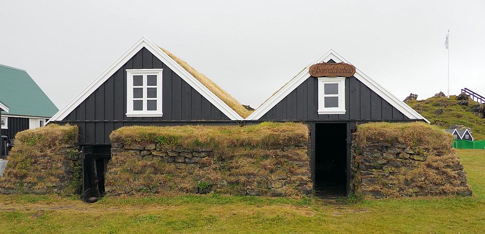
Arbaer Open Air Museum
Arbaer is a “village” of historical Icelandic architecture. If you don’t have the time to travel to Laufas or Glaumbaer, this is the place to view turf houses.
Arbaer Open Air Museum: Kistuhyl, Reykjavik. Open in June-August daily 10:00-17:00; September-May daily 13:00-17:00. Admission: Adults 2,550 ISK, children 0-17 free. Website.
Aurora Reykjavik
This interactive exhibit is all about the Northern Lights. If you’re in Iceland when the day is long, it’s the closest you’ll get to seeing them.
Aurora Reykjavik: Fiskislóð 53, Reykjavik. Open daily 10:00-18:00. Adults 3,900 ISK; children 6-16 1,900 ISK. Information and tickets.
Einar Jonsson Museum
This art museum is home to a collection of sculptures by Icelandic artist Einar Jonsson.
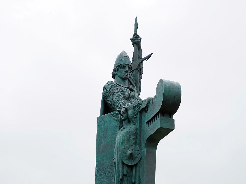
Einar Jonsson Museum: Hallgrimstorg 3, Reykjavik. Open daily 10:00-17:00. Admission: Adults 1,500 ISK; children under 18 free. Combined ticket with the National Gallery of Iceland and the House of Collections: 2,900 ISK; children under 18 free. Website.
FlyOver Iceland
As its name implies, FlyOver Iceland is a flight simulation that sounds like great fun.
FlyOver Iceland: Fiskislóð 43, Reykjavík. Open daily 9:30-19:00. Admission: Adults 5,690 ISK; children 13 and under 3,690 ISK. Children must be at least 100 cm (40”) tall. Information and tickets.
Hallgrimskirkja
Hallgrimskirkja is the famous cathedral that looks like a rocket ship. Made of poured concrete, it’s actually meant to reflect Iceland’s landscape: particularly basalt columns. You can climb up the tower to see the view.

Hallgrimskirkja:Hallgrímstorgi 1 in Reykjavík. Open daily: summers 9:00-20:00 and winters 10:00-17:00. Tower tickets: adults 1,500 ISK; children 7-16 200 ISK. Website.
The Harpa building
This is a stunning concert hall that is definitely worth a look: the glass exterior plays wonderfully with light and shadow. This article on Just Go Places tells more about it and includes some much better photos. I only managed to see it from a distance while I was taking the walking tour.
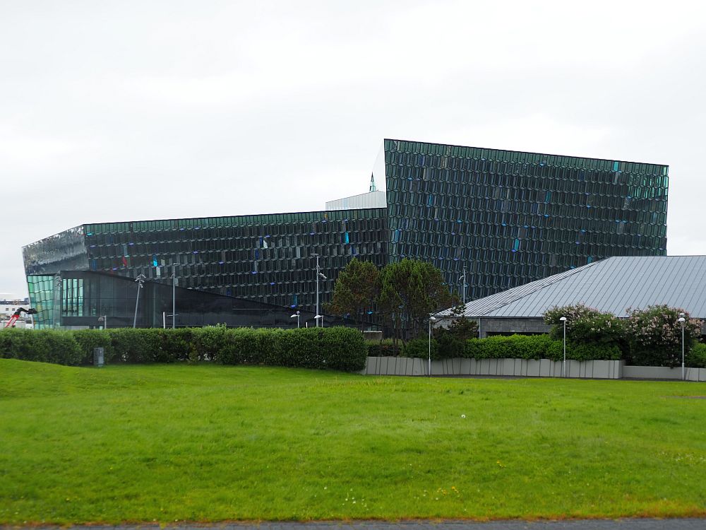
The Harpa Building: Austurbakki 2, Reykjavík. Website.
The House of Collections
This extension of the National Gallery of Iceland houses artworks from the mid-19th century to today, on the theme of “resistance.”
The House of Collections: Hverfisgata 15, 101 Reykjavík. Open daily 10:00-17:00. Admission: 1,500 ISK; children 17 and under free. Combined ticket with the National Gallery of Iceland and the Einar Jonsson Museum: 2,900 ISK; children under 18 free. Website.
Iceland Phallological Museum
Yes, really: this is a museum all about penises. Not just human ones; it includes phalluses from a range of species, including whales.
Iceland Phallological Museum: Hafnartorg, Reykjastraeti 4, Reykjavik. Open daily 10:00 -19:00. Admission 3,500 ISK. Information and tickets.
Icelandic Punk Museum
Lots of punk music-related bric-a-brac inside a former underground public toilet covers Iceland’s punk scene from the 1970s-1990s.
Icelandic Punk Museum: Bankastraeti 2, Reykjavik. Open Monday 10:00-22:00 and Tuesday-Sunday 10:00-18:00. Admission 2,000 ISK; children under 12 free. Facebook page.
Kolaportið Flea Market
This indoor flea market is near the harbor and many of the museums. It has a range of antiques or vintage, but also new odds and ends as well. Since we didn’t want to buy anything, we only walked through quickly.
Kolaportið Flea Market: Tryggvagata 19, Reykjavik. Open Saturday 11:00-17:00 and Sunday 11:00-18:00. Website (only in Icelandic).
The National Gallery of Iceland
Rotating exhibitions from its collection of Icelandic art.
The National Gallery of Iceland: Fríkirkjuvegur 7, 101 Reykjavík. Open daily 10:00-17:00. Admission: 2,400 ISK; children under 18 free. Combined ticket with the the Einar Jonsson Museum and the House of Collections: 2,900 ISK; children under 18 free. Website.
Perlan
In a modern glass-domed building, this interactive experience covers natural phenomena like earthquakes, volcanos and the Northern Lights. It includes an indoor ice cave and lots of interactive features.
Perlan: Öskjuhlíð, Reykjavík. Open daily 9:00-21:00. Admission: 6,890 ISK, children 4,890 ISK. Information and tickets.
Reykjavik Art Museum
The Reykjavik Art Museum has an excellent reputation. However, on the day Albert went, they were transitioning some temporary exhibitions, so only one exhibition was open. He left very quickly, though he was impressed by the few works he got to see.
Reykjavik Art Museum:
- Location Hafnarhús: Tryggvagata 17, Reykjavik. Open daily 10:00-17:00, Thursday 10:00-22:00.
- Location Ásmundarsafn: Sigtún 105. Open daily May-September 10:00-17:00 and October-April 13:00-17:00.
- Location Kjarvalsstaðir: Flókagata 24. Open daily 10:00-17:00.
Admission to all locations, good for 24 hours: 2,550 ISK, children under 18 free. Website.
Reykjavik Maritime Museum
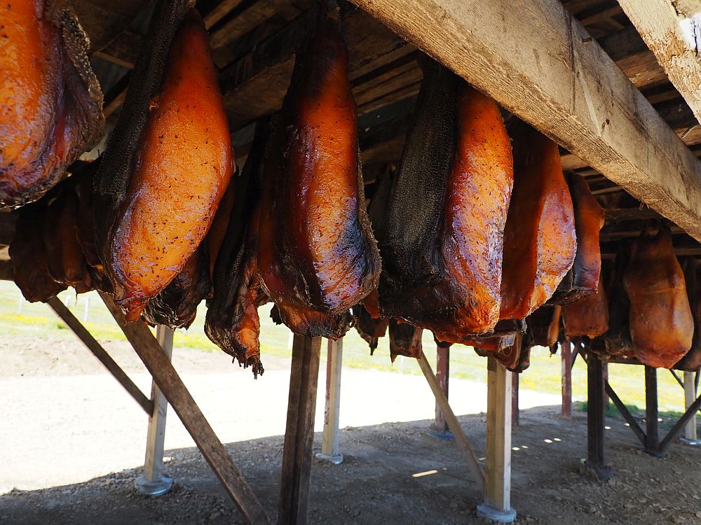
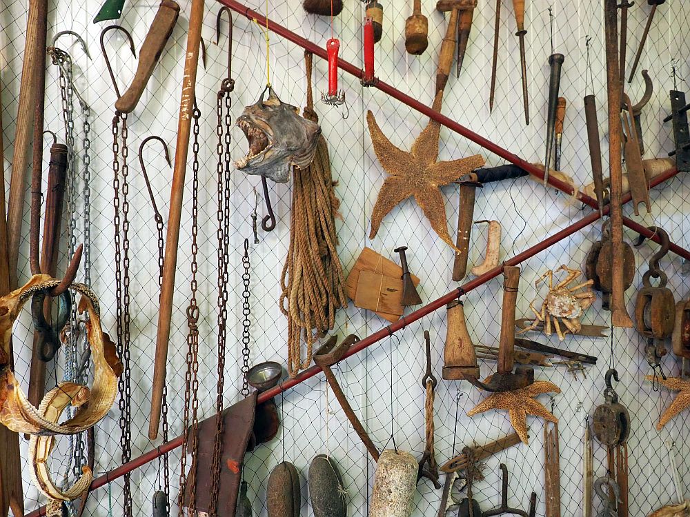
The Reykjavik Maritime Museum is more about fishing than about ships. It’s even housed in a repurposed fish-processing plant. Fishing has always been a key part of Iceland’s economy and in this museum you can learn all about its history, the techniques used in different eras, the life of a fisherman, and so on. It’s generally very well-presented, with lots of multimedia and interactive elements.
Reykjavik Maritime Museum: Grandagarður 8 in Reykjavik. Open daily 10:00-17:00. Admission: 2,550 ISK; children up to 17 free. Website.
Reykjavik Museum of Photography
This museum’s huge collection includes Icelandic and international photographers, both historical and contemporary.
Reykjavik Museum of Photography: Grófarhús, Tryggvagata 15, top floor, Reykjavík. Open Monday-Thursday 10:00-18:00, Friday 11:00-18:00, Saturday-Sunday 13:00-17:00. Admission: Adults 1,400 ISK; children 0-17 free. Website.
The Saga Museum
The Saga Museum in Reykjavik is a bit corny: the kind of thing that’s meant much more for kids than for adults. Unlike the Settlement Center that we visited at the end of our trip (Jump to Settlement Center below), this one covers a number of the Icelandic sagas but, much like the Settlement Center, it presents a blend comprising mostly history, with just a dash of legend.
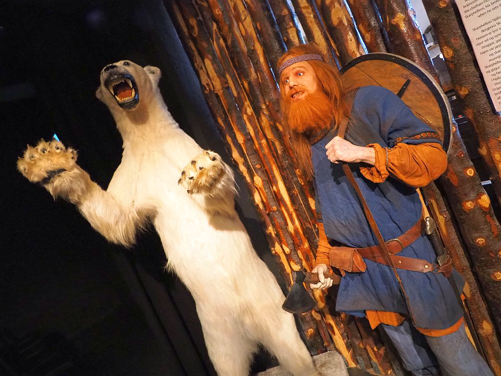
Passing through 17 exhibits, visitors see scenes from various sagas covering Iceland’s early (Viking) history, plus a few from later periods in history. The figures are very lifelike, dressed in clothing and carrying weapons created using traditional techniques. Explanatory signs are in English and Icelandic. Children can dress up as Vikings and pose for pictures on a throne.
The Saga Museum: Grandagardi 2, Reykjavik. Open daily 10:00-17:00. Admission: Adults 4,000 ISK; children 1,200 ISK. Information and tickets.
The Settlement Exhibition (Landnamssyningin)
Iceland is one of the rare places where the term “settlement” isn’t a euphemism for stealing land and decimating indigenous populations. When the Vikings got here in the 9th century, they may have been the only human inhabitants – there seem to be some indications that perhaps a handful of Gaelic (i.e. Irish) monks seeking solitude had spent time on Iceland before then, but that’s all.
Anyway, the Settlement Exhibition is focused on one particular small-scale archeological site: a Viking longhouse in what is now central Reykjavik. Leaving the excavation in place, the building has been shaped around it so that visitors enter a single low room with the excavation, higher than floor level, filling the center.
Displays around the sides show the sparse items excavated from the site – the inhabitants seem to have packed up their belongings when they left. Texts and images explain the history of the place. Projections onto the side walls give an idea of how the landscape around this place looked, with mesmerizing ghostly moving images showing various day-to-day activities.
The excavation itself, at first glance, looks basically like a rock-filled area with a metal mesh holding the edges in place. However, clever interactive explanations all around the ruin make clear what you’re seeing. Pushing a button, for example, shines a light on where the house’s fire was, or where garbage was placed, or where the columns stood that supported the roof. A table screen shows a plan of the longhouse, and we could touch it to get explanations about how each space was used.
The Settlement Exhibition: Aðalstræti 10 & 16, Reykjavík. Open daily 10:00-17:00. Admission: Adults 3,100 ISK, children 0-17 free. Website.
Whales of Iceland
This is just what it sounds like: a museum about whales.
Whales of Iceland: Fiskislóð 23-25, Reykjavík. Open daily 10:00-17:00. Admission: Adults 3,700 ISK, children 7-15 1,850 ISK. Information and tickets.
Days 2-4: Golden Circle sites
Many of the best and most popular sites are within a few hours of Reykjavik. A cluster of them are northeast of the city. You also might have time when you return to Reykjavik at the end of the itinerary to visit sights you missed.
I’ve placed these sights into five groups by location. Sights that are close together can be combined easily. See some of them on Day 2 on your way out of Reykjavik, then in a whole day on Day 3 you should be able to reach two or even three more groups, and possibly another on Day 4.
Accommodations for 2 nights: Reykholt
Somewhere near Laugaras or Reykholt would be central to many of these sights. See what’s available on this accommodations map:
Group 1: Raufarhólshellir lava tunnel, Reykjadalur hot spring thermal river and Kerið Crater
This group, or parts of it, would work on Day 2, on your way out of Reykjavik.
Raufarhólshellir lava tunnel
An option we didn’t take was to see Raufarhólshellir lava tunnel. It is quite near Reykjavik – only about a half hour away – and looks distinctly easier to navigate than the one we visited later in the trip: Vatnshellir Lava Cave. Walkways have been added so you don’t have to stumble around on the gravel during the one-hour tour. That is, unless you want to take their longer tour that takes three-four hours and goes right into the bottom of the cave.
Raufarhólshellir lava tunnel: Take route 1 southeast from Reykjavik, then turn right on route 39. Admission: Adults starting at 8,900 ISK, children 6-15 4,450 ISK, children 3-5 free. Must be booked ahead: tickets.
Reykjadalur hot spring thermal river
This is just what the name says: a hot river. Cooling as it flows away from its source, at a certain point the water is just the right temperature to soak in. At that spot, boardwalks along the banks make it relatively easy to get in and out of the water and protect the riverbanks at the same time.

To get there, though, you have to hike about 3.5 kilometers (2.2 miles) each way from the parking lot, mostly uphill to get there and mostly downhill to get back. The path is gravel, with stretches where the gravel is made up of quite large rocks.
You can read all about this hike, along with some advice from walking it, in my separate article about my experience.
Kerið Crater
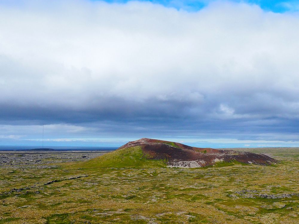
Kerið Crater is, obviously, a crater. To be more specific, it is a large scoria crater that formed about 6,500 years ago in a volcanic eruption, after which a small magma chamber beneath the crater emptied, causing it to collapse.
The crater is known for its striking blue water, which stays at the level of the water table. The sides have very little vegetation on them: just some low moss or grass and a few low wildflowers. Visitors can walk around the rim on a gravel path to see the crater from all sides. Make sure to admire the scenery in all directions; you’ll see some dramatic landforms and even more dramatic cloud formations.
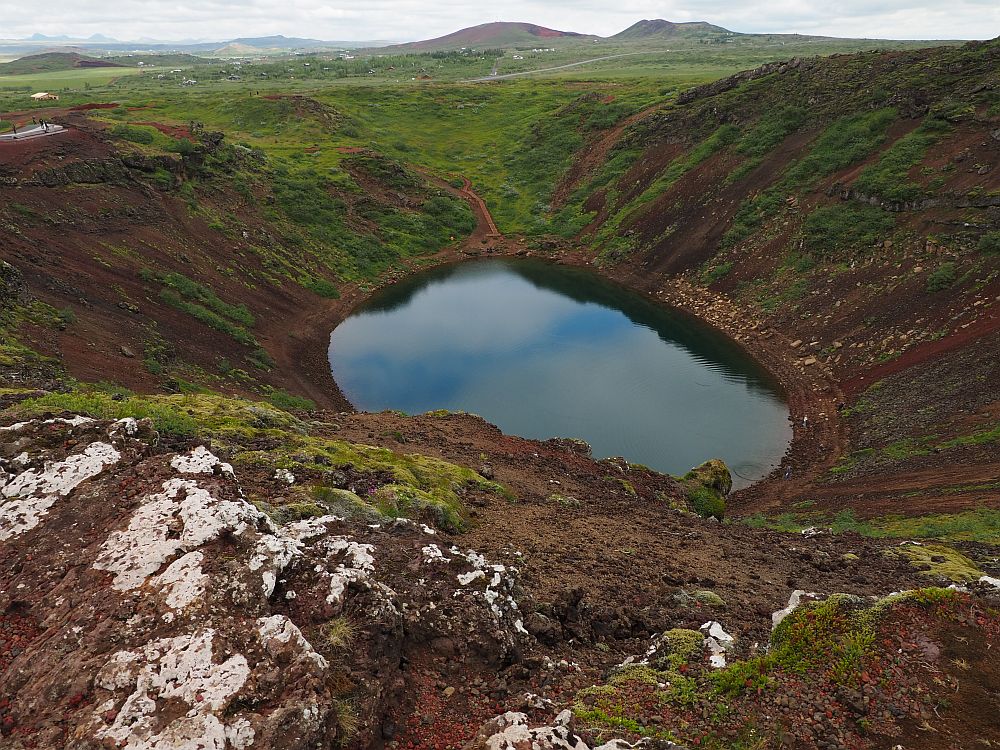
A stairway leads down to the water and a small path circles the edge of the water. Make sure to stay on designated paths to avoid damaging the crater and to keep safe.
We visited Kerið Crater on a cloudy day and the water in the crater wasn’t all that blue. A constant theme of a trip around Iceland, though, is wonder at the power of volcanic activity, and this crater is a good example of that.
Kerið Crater: 15 km north of Selfoss on route 35. Open during daylight hours. Admission: Adults 600 ISK; children 0-6 free. Tickets.
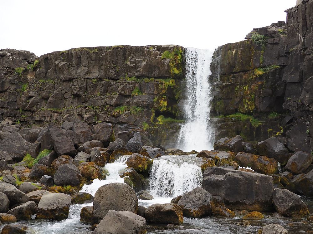
Group 2: Thingvellir National Park and Oxararfoss waterfall
Thingvellir National Park
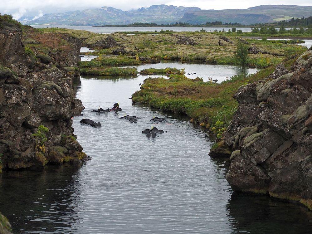
More properly spelled as Þingvellir, this UNESCO-listed site is important for two reasons: one historical and the other geological. We wanted to see both.
Þingvellir was the seat of government in what is called the “Old Commonwealth” period, starting in 930 AD. There’s not much left of the original site, but there’s an excellent interactive exhibition called “Heart of Iceland” in the Hakið visitor center in the park.
As for geology, Þingvellir is known as the only place where the Eurasian and North American tectonic plates are visible on dry land. You can even go snorkeling or diving between the two plates at Silfra in the park.
For more information about Thingvellir, read my article 7 Things to do in Thingvellir National Park.
Þingvellir National Park: Take route 1 out of Reykjavik and turn right onto route 36. The exhibition at the Visitor Center is open daily April-October 9:00-18:00 and November to March 9:00-17:00. Visitor Center admission: 1,200 ISK; children under 18 free. While admission to the park is free, if you park in P1, P2 or P5, you’ll have to pay for parking either at pay machines or online here. Don’t forget or your rental car company will likely add an additional charge on top of the parking fee. Þingvellir’s website.
Book a Silfra diving or snorkeling package here.
Öxarárfoss
Inside Þingvellir National Park, you’ll find Öxarárfoss waterfall. It’s an easy walk either from the visitor center or from a nearby parking lot. While it is pretty, it doesn’t compare to some of the others we saw on this trip, a couple of which are in Group 4 below. Read my article about waterfalls in Iceland to see what I mean.
Group 3: Secret Lagoon or Hruni hot spring, and Skalholt
The Secret Lagoon
In my research before this trip, I found that the Secret Lagoon is often seen as a cheaper alternative to the famous Blue Lagoon, which is why we chose to go there. Read my post about the thermal baths we visited for a detailed description and to help you decide which ones to splurge on. I liked it because it has a bonus: a miniature geyser, right next to the pool.
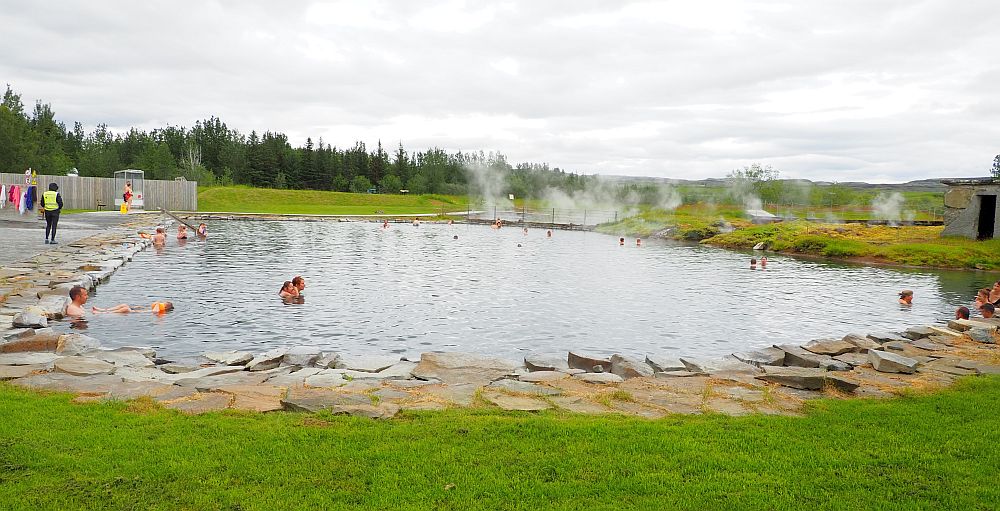
The Secret Lagoon: Hvammsvegur, 845 Flúðir. Open daily October-May 10:00-19:00; June-September 10:00-20:00. Admission: 4,500 ISK; children under 15: 260 ISK. It’s wise to book ahead.
Hruni Hot Springs (Hrunalaug)
This rustic hot spring is right next to the Secret Lagoon. We didn’t visit it because we figured one was enough in a day. It was originally just a small concrete pool, but it’s been upgraded recently with a new small pool to accommodate tourists. It stands on private land, and there’s now a hut for changing in (no lockers), and toilets near the parking lot.
Hruni Hot Springs: Sólheimar, 846 Flúðir. Open May-August 9:00-23:00; September-October and March 15-April 9:00-21:00; and November 1-March 14 10:00-20:00. Admission: 3,000 ISK; children 11-15 2,000 ISK; under 11 free. Website.
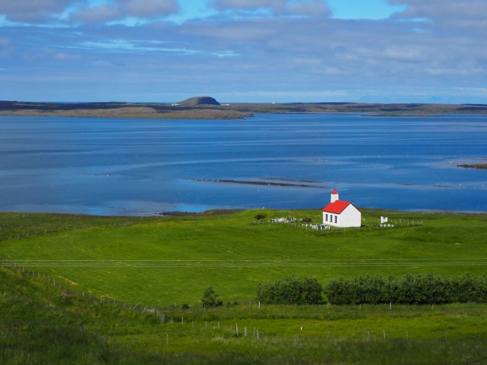
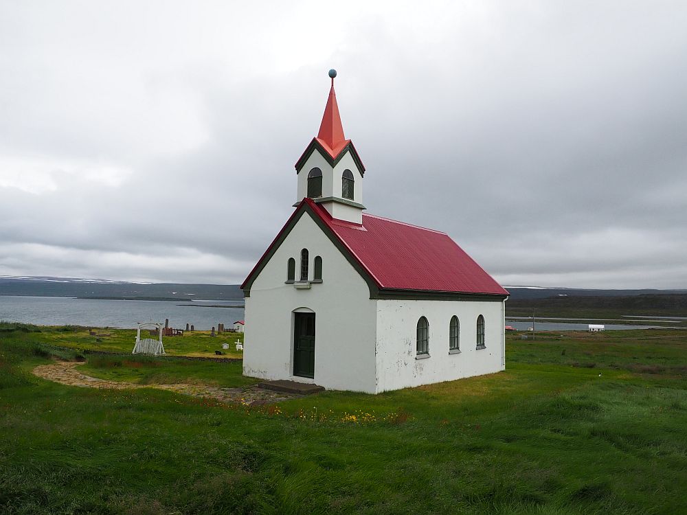
Skalholt
Checking in to our accommodation for the next three nights, we passed the small village of Skalholt, shining white in the evening sun just off the main route. We decided to return the next day. The pretty white church (1956-63) has some unusual artworks scattered outside, and a rather impressionistic painting above the altar. Skalholt also has a reconstruction of a turf church.
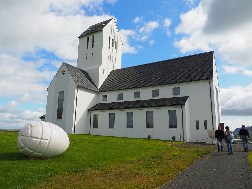
Skalholt: The church is open daily 9:00-18:00. Church website.
Group 4: Fontana Hot Baths, Bruarfoss waterfall, Strokkur geyser and Gullfoss waterfall
Fontana Hot Baths
Fontana Hot Baths was a pleasant place to relax for us, with a range of pools of various temperatures, all overlooking a pretty lake. You can read about it in more detail in my article about the thermal pools I visited. If you didn’t get to the Secret Lagoon yesterday, though, I’d recommend the Secret Lagoon above Fontana. I prefer the natural sulphur smell of the Secret Lagoon to the chlorinated water in most of Fontana’s pools. On the other hand, Fontana has a lake next to it if you like cold plunges.
Fontana Hot Baths: Hverabraut 1, Laugarvatn. Take route 36 from Reykjavik toward Þingvellir. Leaving Þingvellir it becomes the 365. You will find Fontana right after it joins route 37. Closed for maintenance until April 2026. Open from June 1, 2026 daily 10:00-21:00. Admission: Adults – 7,490 ISK; children 10-16 – 4,500 ISK; under 10 – 800 ISK. Tickets.
Bruarfoss waterfall
Bruarfoss is actually a series of three waterfalls and requires much more walking to see: about three kilometers (almost two miles) each way. Without a doubt, it’s worth it. The last of the three is Bruarfoss, a wide waterfall, but with a cleft in the middle. The rapids on both sides tumble into the cleft. This waterfall is best known for the distinctive blue color of the water. Read more in my post about waterfalls.
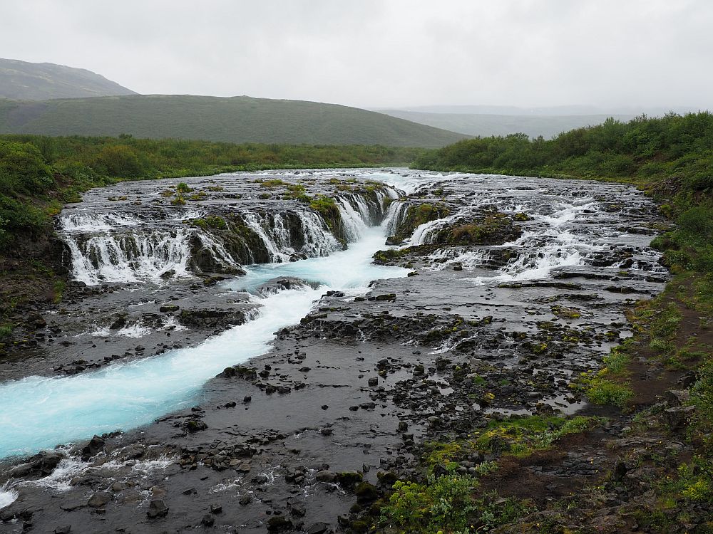
Bruarfoss: Leave your car at the place along Route 37 marked as “Bruarfoss waterfall official parking” on Google maps. Follow the path along the river. Open all the time. Free admission, but there’s a fee for parking. Use the Parka app or website.
Strokkur Geyser
Strokkur Geyser is billed as erupting about every 8-10 minutes, but it was more often when we were there. Often it erupted two or three times in quick succession. Then the wait was about eight minutes before the next cluster of two or three.
If you’ve been to Old Faithful in Yellowstone, this geyser might disappoint you because it’s not as big. It is fun to watch, though, and I particularly enjoyed the squeals of kids each time it erupted. It’s quite a show.
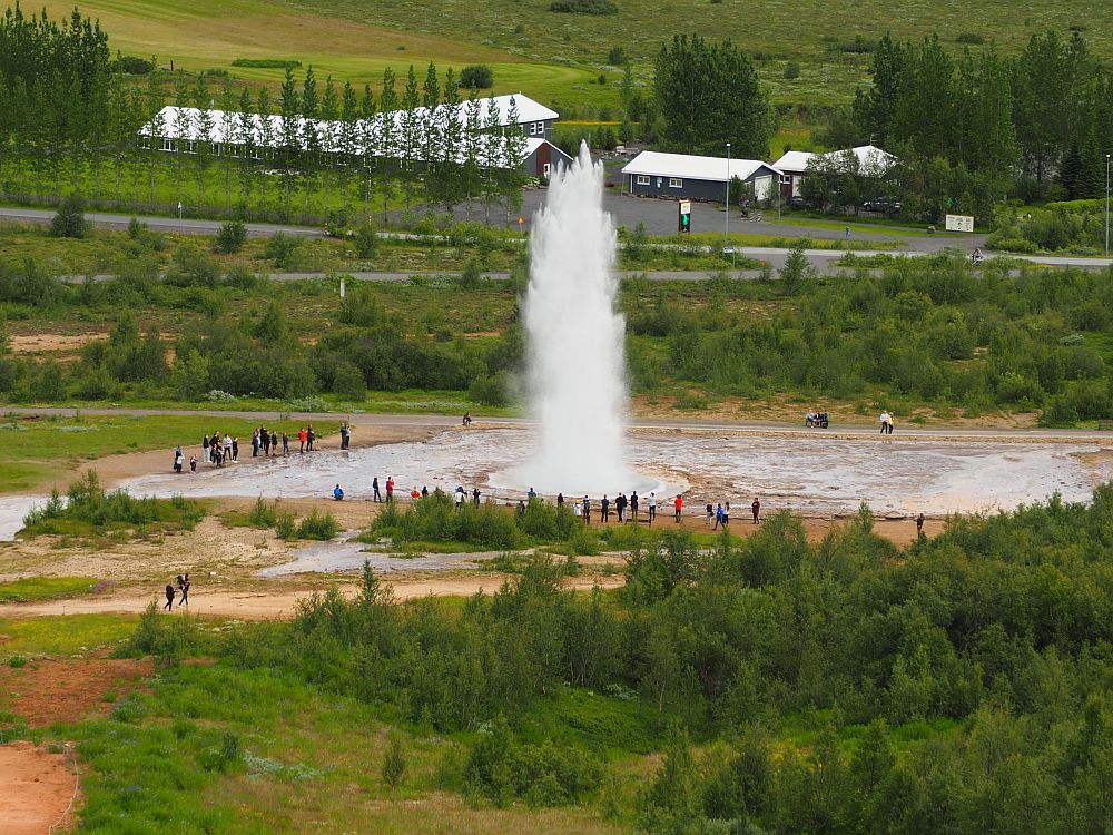
Beyond the geyser is a range of bubbling pools and still pools that quietly steam. You can climb the hill above Strokkur to get a view from above, as well as over the surrounding green countryside.
Strokkur geyser: Route 35, about an hour and a half from Reykjavik. Open every day and 24 hours a day. No admission fee, but there’s a fee for parking. Use the Parka app or website.
Gullfoss Waterfall
Gullfoss waterfall is a two-parter and it’s simply magnificent. Quite wide at first, it tumbles over a broad, flat shelf of rock, but then forms a steeper, narrower falls into a deep gorge. You can read more about it in my waterfalls of Iceland article. It is an easy one to drive to, with little walking necessary.
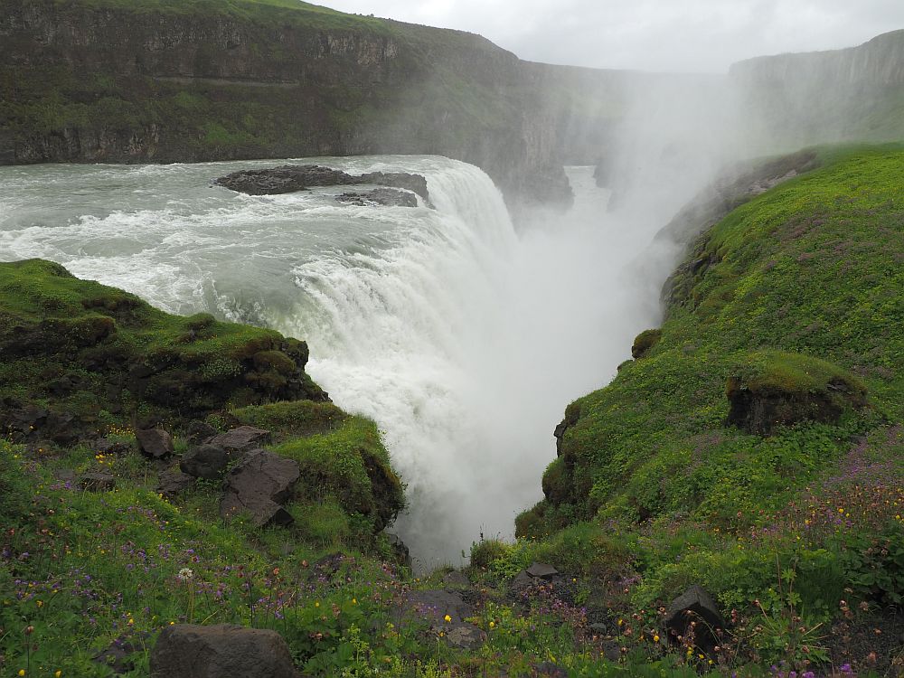
Gullfoss: Continue past Strokkur Geyser on route 35. Always open. Visitor center open during daylight hours. No fee.
Group 5: Stong Viking farmhouse and Haifoss waterfall
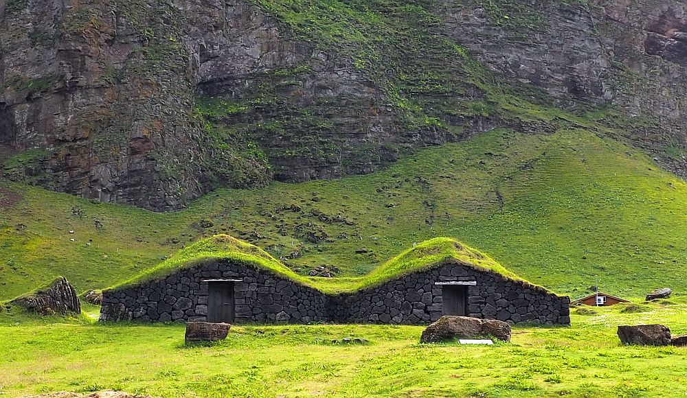
Stong Viking farmhouse (Commonwealth Farm)
Based on an archeological excavation, Stong Viking farm is a reconstruction of a Viking longhouse, built largely of turf blocks for walls and roof. I wrote about it in my article about turf houses.
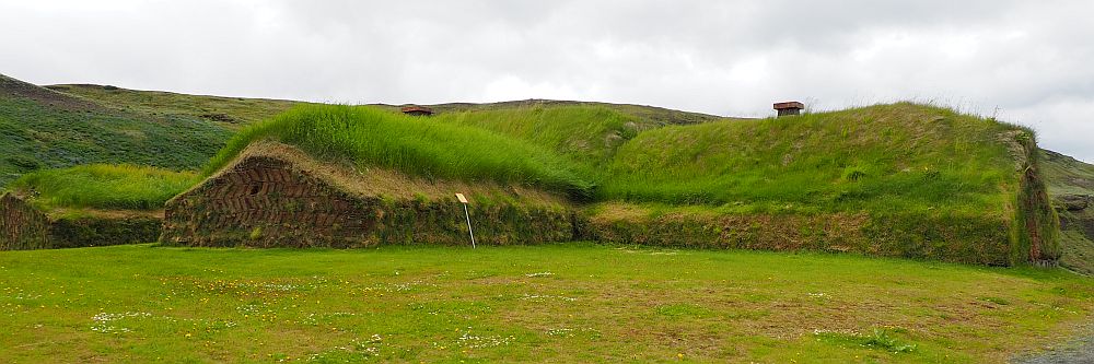
Stong Viking farmhouse: Þjórsárdalur, about an hour and 45 minutes east of Reykjavik. Open daily 10:00-17:30 in May to mid-October. Admission: Adults 2,500 ISK; Children 6-12 are 500 ISK. Website.
Haifoss waterfall
Haifoss waterfall is actually two waterfalls: Haifoss and a smaller, narrower neighbor called Granni. Both tumble over a steep cliff to form a canyon below. The road to them is quite bad, and it’s a judgement call whether you should take it if your car isn’t four-wheel drive. We did, and certainly thought it was worth it. You can read more about it in my post about waterfalls in Iceland.
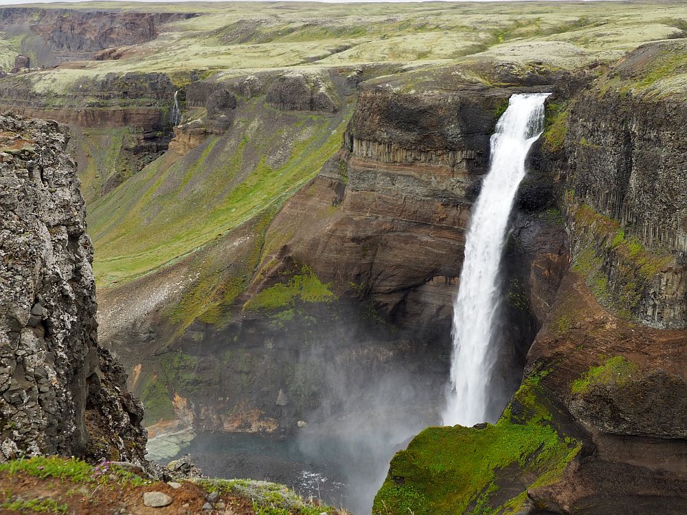
Haifoss waterfall: Off Route 32, 7.5 kilometers each way on Route 332: not an f-road but “impassable.” Hitchhiking or walking might be preferable. Nevertheless, we drove it in a two-wheel drive car extremely slowly, taking about 20 minutes each way, risky if you haven’t paid for full coverage on the rental car. Always open. No admission fee.
If you are looking for a more compact, skimmable version of this 3-week Iceland itinerary, you can get mine for free in exchange for subscribing to my once-a-month newsletter. Use the form below:
Days 4-6: Heimaey, Vestmannaeyjar
On Day 4, take the ferry to the Westman Islands, more correctly known as the Vestmannaeyjar archipelago. This is a cluster of islands off the south coast of Iceland. Only one is inhabited year-round: Heimaey, your destination. Heimaey’s population is about 4000, on 13 square kilometers (5 square miles) of land.
The ferry to Heimaey
A ferry runs between the town of Landeyjahöfn and Heimaey several times a day and can be booked ahead. Here is the website for the ferry. You’ll pass a number of smaller islands on the way.

If you are going to bring your car across, you’ll need to book ahead. It’s not strictly necessary, though, if you are happy walking everywhere on the island. It might mean you can’t see as many of the sights, though.
Accommodation for 2 nights: Heimaey
We stayed in Guesthouse Árný, right in town. Our room was down in the basement, but had a window with good blackout curtains, which we appreciated. It had enough of a kitchenette for us to cook a simple dinner. The fridge was in the hall and shared with one neighboring room, as was the bathroom across the hall. It was all clean and comfortable and the host was very friendly. For an extra charge, breakfast is served upstairs in a glassed-in room.
There are plenty of other options on Heimaey:
Lava Centre
On the way there, you could easily stop at Lava Centre. This is an interactive museum teaching all about volcanoes, lava, earthquakes, etc. Unfortunately, we missed this in our rush to get to the ferry.
Lava Centre: Austurvegur 14, 860 Hvolsvöllur. Open June-August 8:30-19:00 and September-May 8:30-17:00. Admission: Adults 5,200 ISK; chlidren 6-15 2,600 ISK. Tickets.
What to see in Heimaey
The island includes a number of sights, which you can read about in more detail in my article about the island. Here is an overview:
- Eldheimar Volcanic Museum: This little museum focuses on the 1973 volcanic eruption on Heimaey Island which forced a total evacuation and then, over several months, added land to the island, making it 20 percent bigger than before. Suðurvegur / Gerðisbraut 10, Vestmannaeyjar. Open daily April to mid-May 13:00-16:30 and mid-May-mid-September 11:00-17:00. Admission: Adults 3,550 ISK, children 10-18 1,900 ISK. Tickets.
- Eldfell Crater: This crater, formed in the 1973 eruption, has a trail leading to the top for a view of the island. Open all the time. No fee.
- Sea Life Trust: Pretty minimal as far as aquariums go, the Sea Life Trust is a sanctuary for rescued whales, and they also deal with rescued puffins. The aquarium has lots of information about the whales and how they came here from a commercial aquarium in Japan. Ægisgata 2, Vestmannaeyjabær. Visitor Center open daily mid-February to early May 11:00-15:00; early May-mid-September 10:00-16:00; mid-September to mid-November 11:00-16:00. Visitor Center admission: from 3,560 ISK; children 6-12 2,610 ISK. Website.
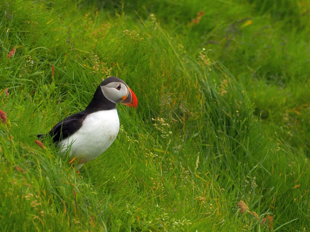
- Puffins: The very southern tip of the island is a bird sanctuary. The parking area below the top of the hill is where you can find a bird blind that is perfect for observing the puffins during nesting season in June to September. Take a walk around the southern point of the island and you’re likely to see more of them. Open all the time. No fee.
- Landlyst Medical Museum: In one of Heimaey’s oldest buildings, this tiny museum tells the history of medical care in Heimaey, which came late and was pretty minimal. Skansinn, harbor area. No fee.
- Sagnheimar Folk Museum: A typical local museum with a mix of topics: the 1973 eruption, a pirate raid from 1627, the fishing industry, etc. It’s pretty well-presented with some multimedia touches. Hasteinsvegur, upstairs from the library, Heimaey. Open daily May-September 10:00-17:00, October-April Monday-Saturday 12:00-15:00. Admission: 1,300 ISK, children under 18 free. Website.
- Herjólfur’s Farmhouse: a reconstructed Viking-period farmhouse. Dalvegur, Heimaey. Open all the time. No fee.
- Blátindur mountain: a curved ridge above Herjólfur’s Farmhouse has several paths you can climb to a path at the top along the ridge. Best avoided if it’s windy. Open all the time. No fee.
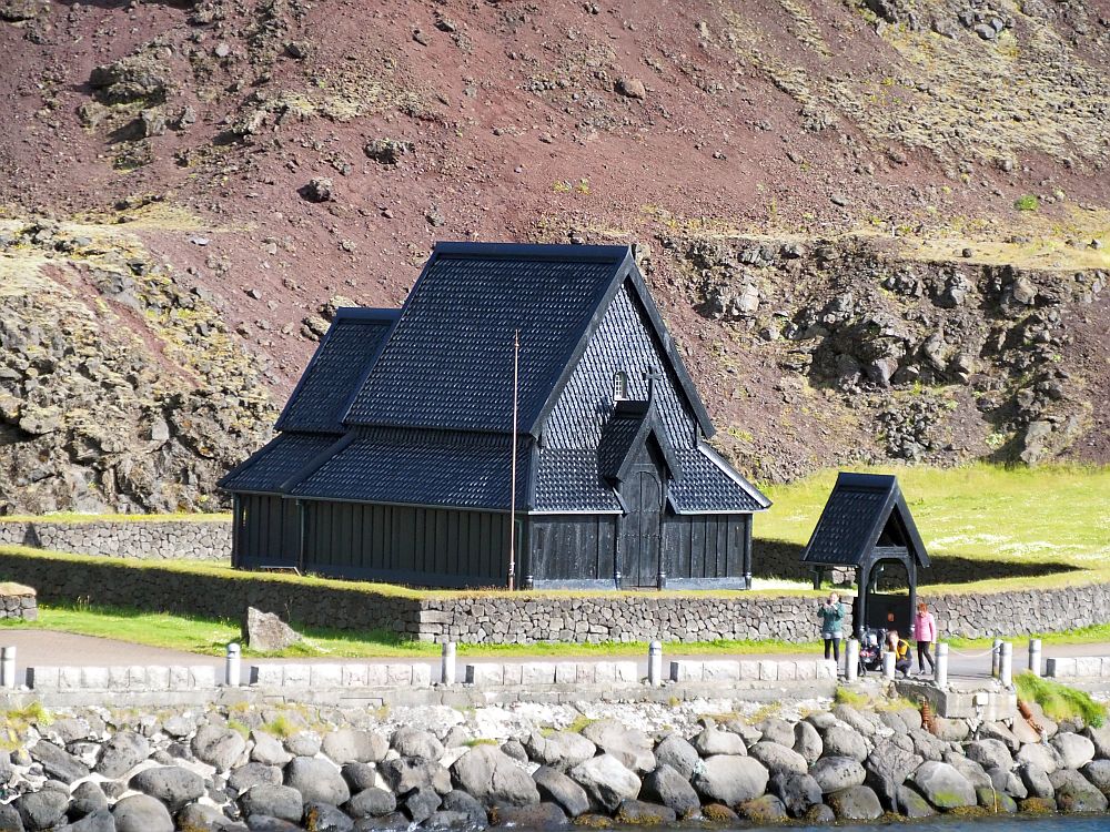
- Heimaey stave church: In the Skansinn area at Heimaey’s harbor, this is a copy of a stave church in Norway, given by Norway as a gift on the 1000th anniversary of Iceland’s conversion to Christianity. Skansinn, harbor area. Open all the time. No fee.
All the details about Heimaey are here: Things to do in Heimaey island, Vestmannaeyjar, Iceland.
Day 6: Heimaey to Vik
Leave Heimaey on the ferry in the morning and head east on Route 1 (Unless you need to backtrack to the Lava Centre.) There are a lot of choices of things to see today, and you might not be able to see them all.
Accommodations for 1 night: Vik
Accommodations in or near the village of Vik I Myrdal would be the most convenient place to end your day.
Accommodations near Vik:
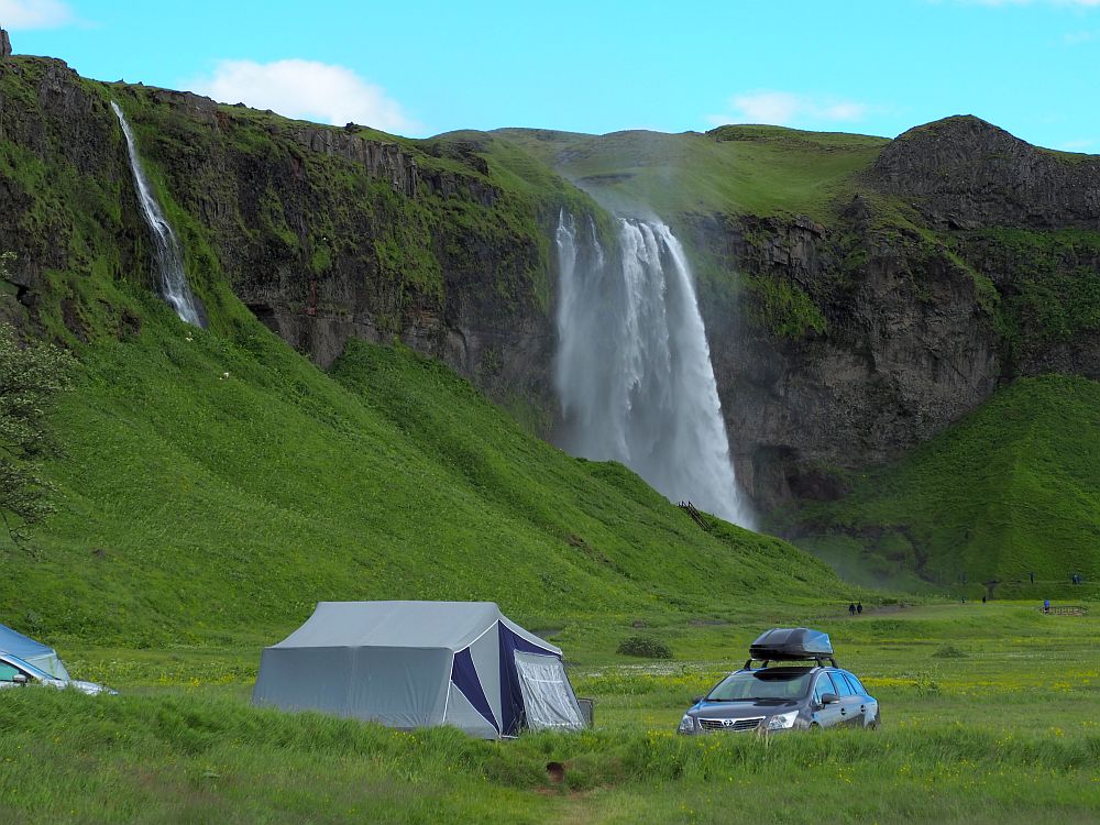
Gljúfrabúi and Seljalandsfoss waterfalls
Seljalandsfoss waterfall is well-known and much-visited, largely because it is right on the ring road and because you can walk behind it. We didn’t, partly for lack of time but also because the parking fees were high for the short visit we intended. It is quite beautiful though: a simple straight downward curtain of water, made more interesting because of the effect of wind blowing the water around.
Gljúfrabúi and Seljalandsfoss waterfalls: Hvolsvöllur. Just past where you turn onto Route 1 from the ferry, you’ll cross a bridge and the turn-off is on the left after the bridge. Always open, no fee, but there is a parking fee per day. Pay on-site or via Check-it.
Skogar
The little village of Skogar is right on the ring road. We ended up spending several hours there because there was so much to see. I’ve written a separate post about Skogar, which you can read here. Below is a summary of what we saw:
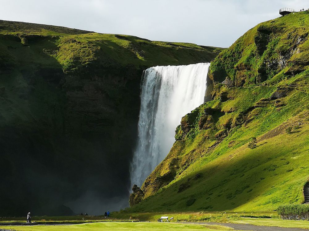
- Skogafoss waterfall is a long, wide, straight one and can be viewed from two perspectives. At the bottom you can see the whole length of it, and you’ll probably get wet from the spray. You can also climb a long stairway to the right of it to a platform at the top to see it from that point of view. Turn left from Route 1 into Skogar village; drive through the village and you’ll spot Skogafoss to the left. Always open, no fee, except for parking. Use the Parka app or website.
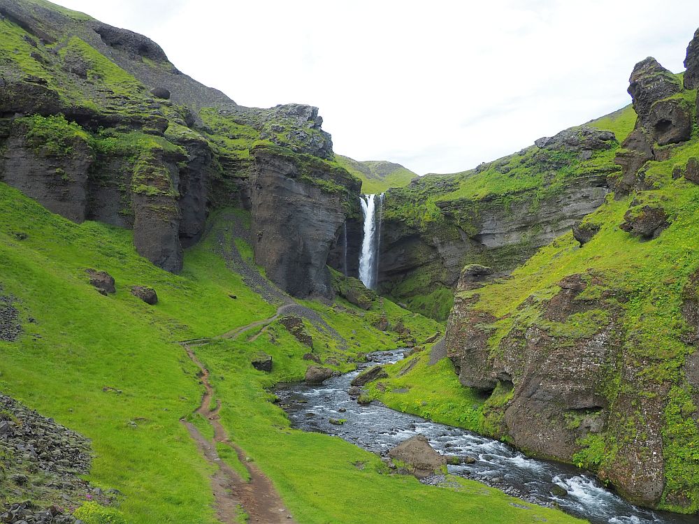
- Kvernufoss waterfall is smaller than its neighbor, but we loved it. I cover both Skogafoss and Kvernufoss in my article about the waterfalls of Iceland. Park at the Skogar museum, walk past the technology building and you’ll see the beginning of the trail. It’s not a long or difficult walk, but does involve climbing a stile. Open all the time. No fee.
- The Skogar Museum is three museums in one: a folk museum, an open-air museum and a technology museum. As you enter Skogar village, you’ll see a sign to the museum to the right. Open daily June-August 9:00-18:00 and September-May 10:00-17:00. Admission: 2,750 ISK, children 12-17 1,500 ISK. Website.

Solheimajokull glacier
When we visited Solheimajokull glacier, we knew enough not to even consider walking on it. People who walk on glaciers without a guide have a distinct tendency to die. Besides, Albert had a guided glacier walk booked in a few days, but we were curious to see one.
Since we hadn’t booked a guided walk, we could only approach a fairly short distance from the car park, at which point access is marked off with a rope and some strongly-worded signs.
Nevertheless, it’s an impressive scene. In front of us was a glacial melt lake: smooth water with a few icebergs floating in it that had broken off from the glacier. The glacier itself was at the far end of the lake, and it was huge. I know that glaciers move and flow much like rivers, and this one looked like a river had just frozen in its tracks, after which bits had broken off. It is a massive body of ice – one or two kilometers wide and 14 kilometers long – extending up a mountain.
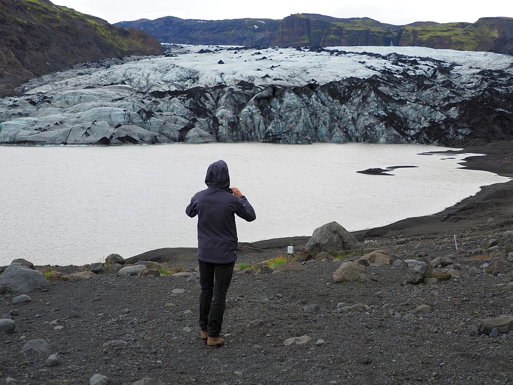
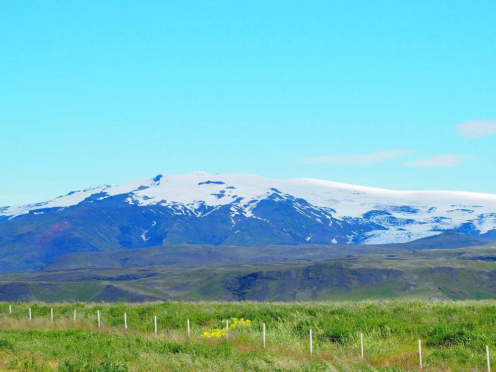
I found out later that Solheimajokull glacier is only one finger from a much larger one called Mýrdalsjökull. Mýrdalsjökull, in turn, covers an active volcano called Katla. Solheimajokull glacier sits between Katla and another ice-cap-covered mountain called Eyjafjallajökull. That’s the volcano that erupted in 2010 and caused so much disruption to flights all over the world for a week or more.
Solheimajokull Glacier: Take a left from Route 1 onto route 221 to the parking lot. You can walk a short distance toward the glacier but not past the fenced-off area. Parking area is always open. No fee.
It was just our first week in Iceland and all of these active volcanos, boiling water sources, lava fields and such were beginning to get me nervous. I knew that Iceland had volcanos. I just didn’t realize how active it is, geologically speaking.
If you look on this site, you’ll see that Iceland has dozens of earthquakes every month, most of which are under 4.0 on the Richter scale. However, in October 2020, as I was writing this, an earthquake of 5.6 hit on the peninsula to the west of Reykjavik.
Solheimasandur plane wreck
We did not take the time to see the Solheimasandur plane wreck because, frankly, it didn’t seem worth the trouble. Nevertheless, it has to be the most – or at least one of the most – instagrammed sites in Iceland.
The plane is a US Navy DC-3 that crashed on this beach back in 1973. You can read more specific information at Finding the Universe.
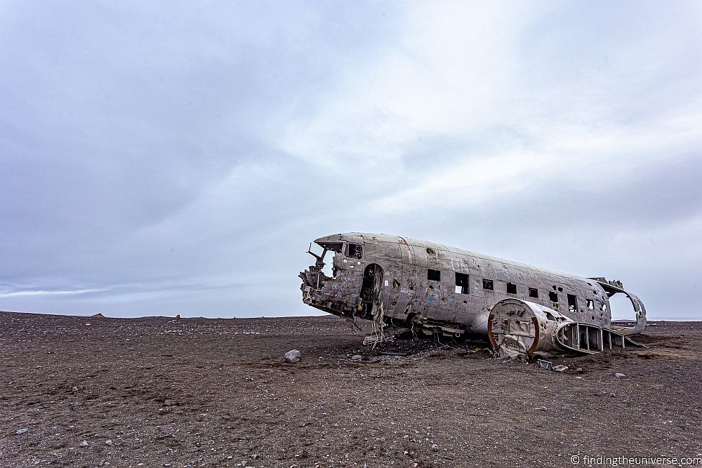
Solheimasandur plane wreck: Park in the pull-off on route 1 and follow the marked path, mostly flat, from there, 4 kilometers each way (2.5 miles). A new shuttle service takes about 10-15 minutes each way, if you don’t want to walk. Open all the time. No fee.
Dyrholaey Nature Preserve
Dyrholaey is a high promontory with cliffs on three sides in the middle of a mostly beach-lined coast. Because it stands alone above black sand beaches, it is a magnet for birds, which nest in the cliffs. We went to Dyrholaey to see the birds.
The top of the promontory is flat, and paths are marked and edged with rope to prevent people from a) falling off, b) damaging the plant life and c) disturbing the birds. Besides a lighthouse, painted bright orange on top, there are no buildings.
Facing the sea, on the right is a long stretch of flat black-sand beach. On the left, another black-sand beach, this one the much-visited Reynisfjara beach. Around the cliffs below, a range of rock formations on the beaches or in the water.
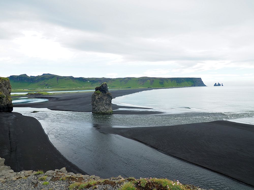
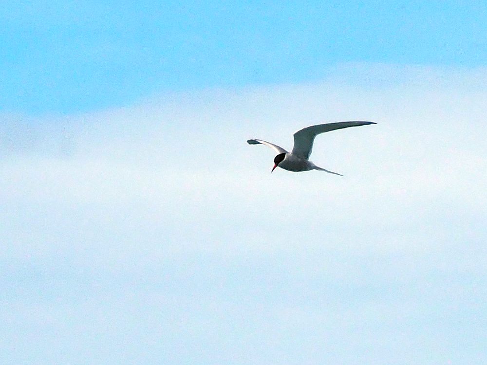
The cliffs that are visible, along with the rock formations in the sea, absolutely teem with bird life … at least they did in July. I saw lots of gulls especially, and also some puffins whizzed by.
The sea has carved arches in one of the rock formations, and it’s shaped others into needles of rock over the centuries.
Make sure to look land inwards as well, where you’ll see the glacier-topped volcanic mountains in the distance, and green farmland between them and the coast.
We spent a good two hours at Dyrholaey: it was excellent birdwatching.
Dyrholaey Nature Preserve: Route 218 is a right off of Route 1. Open all the time. No fee.
Reynisfjara Beach
After lunch we made a stop at Reynisfjara Beach, even though we’d already seen its famous rock formations (basalt stacks) in the distance from Dyrholaey. Apparently they appeared in some “north of the wall” scenes in Game of Thrones.
It’s easy to get to the beach: right off route 1, it just takes a short walk from the parking lot, but then you can walk to your heart’s content along the black sand beach. Be careful, though. The beach is known for “sneaker” waves that catch selfie-takers unawares. Tourists have died here.
Reynisfjara beach has a great example of basalt columns: naturally-occuring hexagonal columns. A wall of them invites people to sit and pose. There’s a cave on either side of the basalt columns. The one to the right of the wall is most interesting. There, the columns have been undercut by the water, I assume, and eroded, forming a cave roof made of natural hexagonal tiles.
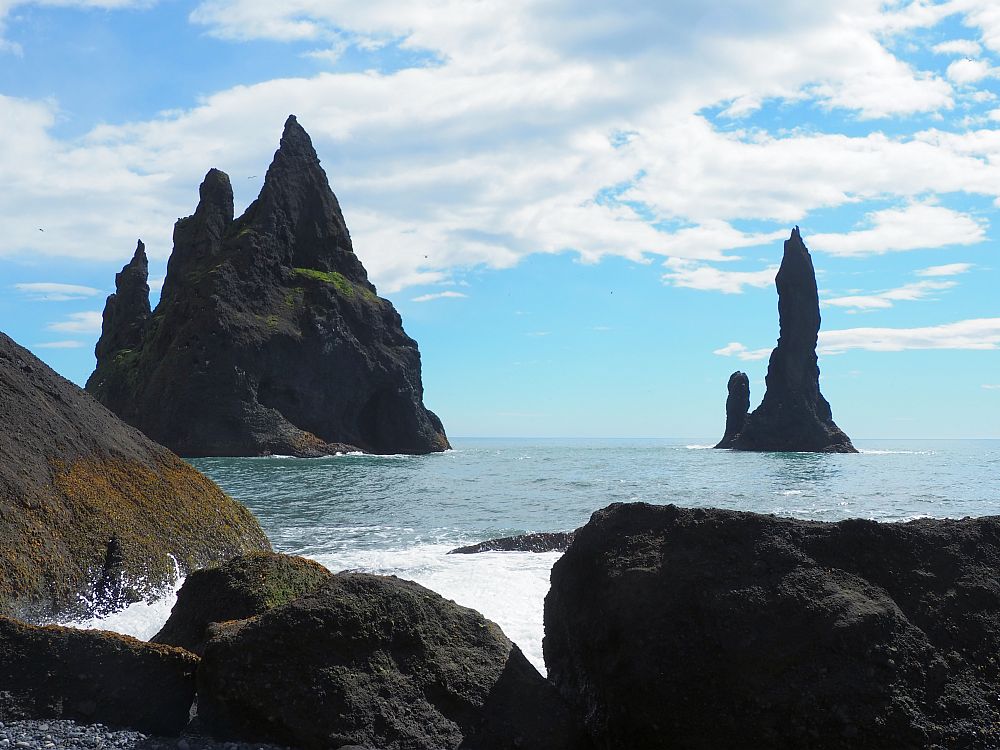
Reynisfjara Beach: From Route 1, take a right onto route 215. The parking lot is right next to the beach. Always open. No fee, except for parking. Use the Parka app or its website.
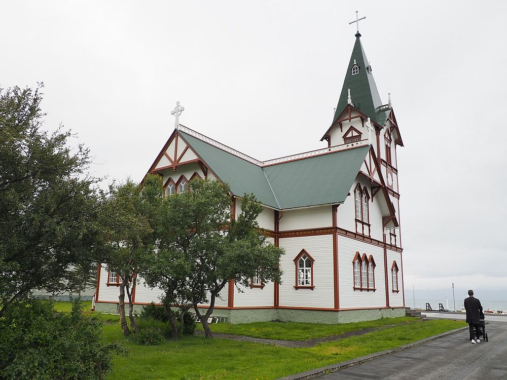
Vik
The little town of Vik, on the southernmost part of Iceland, besides being a good place to stay, is also a good place to pick up supplies.
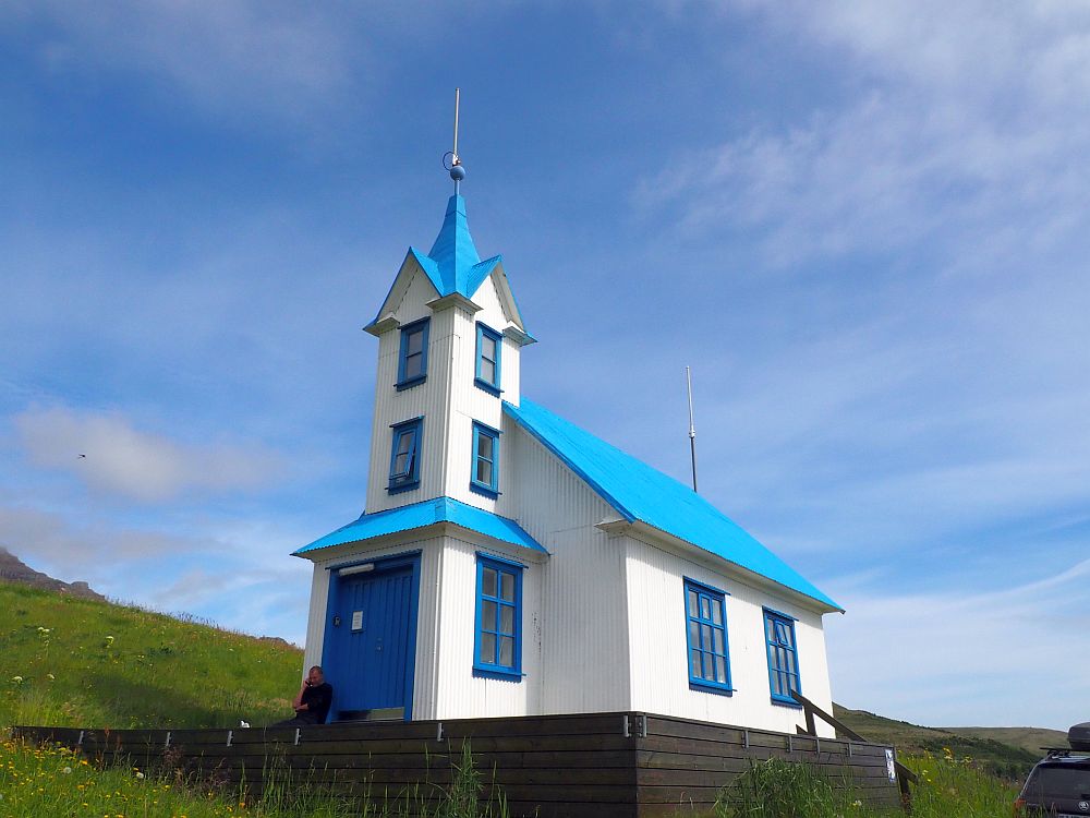
What I particularly wanted to see as well was Vik’s church. It’s not very old (1934), but it’s certainly picturesque. From the church’s position on a hill, we could also get a good view of the ocean and some basalt column formations off the coast.
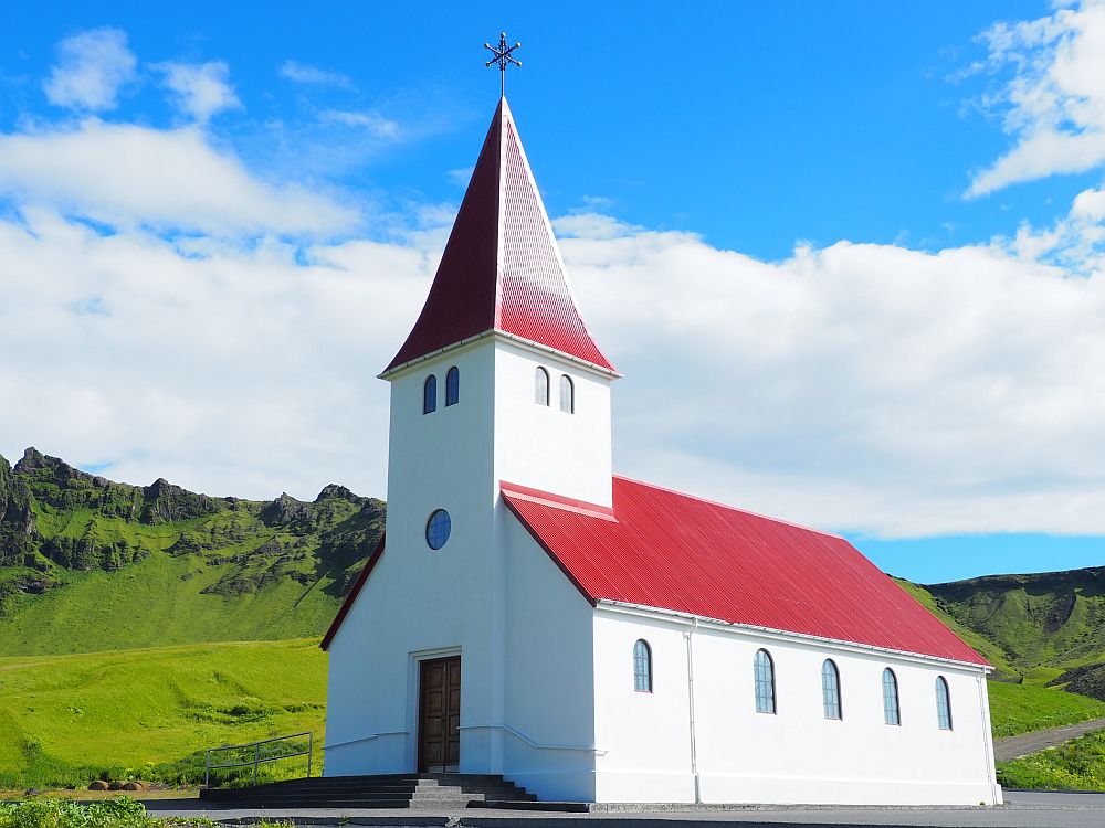
Vik’s church: You’ll see it from a distance. Take a left in Vik onto Suðurvegur, then a right onto Hátún. It was closed when we stopped there, but presumably is open for Sunday services.
Day 7: Southeastern Iceland
Today would be a good day to plan any activities like glacier hiking.
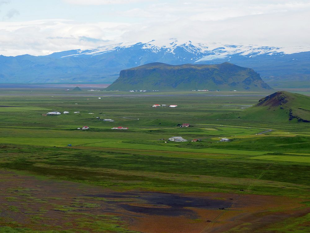
As you leave Vik in the morning, you’ll be driving along the edge of Katla UNESCO Global Geopark. Mount Katla, to your left, is a glacier-covered volcano that last erupted in 1918. Judging by its record since the first settlers came to Iceland in the 9th century, Katla is overdue for an eruption.
Accommodations for 1 night: Höfn
We stayed at the Seljavellir Guesthouse in Höfn í Hornafirði, the most hotel-like of all the places we stayed on this whole trip. It’s a long double row of rooms, like a motel, but with a more Scandinavian vibe. Breakfast costs extra and isn’t anything special, but it’ll do. The room was very comfortable and quiet, with a pretty view.
There are plenty of other places to stay near Höfn, of course. Book Höfn accommodations by clicking on the map below:
Fjaðrárgljúfur Canyon
A river dug out Fjaðrárgljúfur Canyon over the past 9000 years. It is about a kilometer long and 100 meters deep and meanders picturesquely from a waterfall down to the sea.
Seeing the canyon requires some walking, but none of it is difficult. The path is well-marked and well-maintained, though occasionally it’s uneven. Clearly in the past it wasn’t so well-marked: it’s easy to see the damage that the selfie-taking crowd has inflicted on some parts of the cliff that extend out into the canyon. The side paths to these points are well-worn (i.e. damaged), but nowadays they are fenced off. Please stay on the marked path. Besides the damage it causes the plants, the edges are also susceptible to crumbling, making it dangerous.
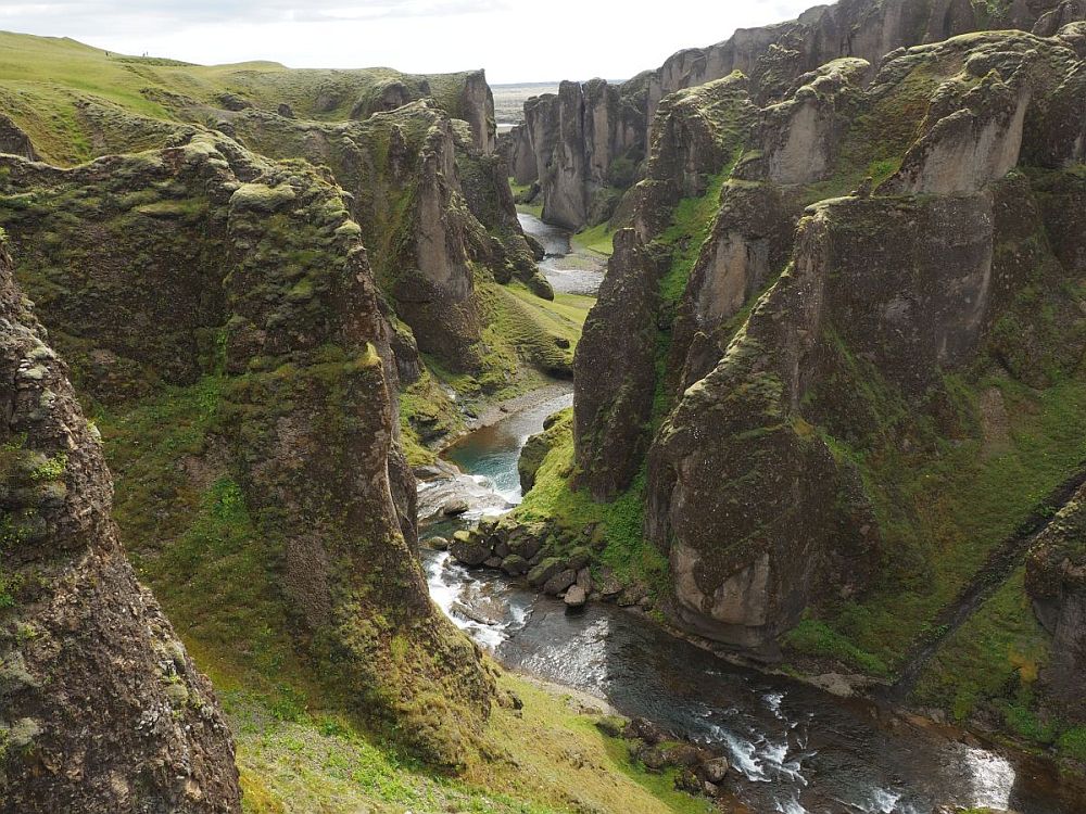
A viewing platform overlooking the waterfall has good solid railings but the floor is a metal grid, allowing a straight view down. With my fear of heights, this made me a bit nervous.
It is also possible to walk at the bottom of the canyon along the river, but we didn’t. It looks like in places, where the land extends out to form steep cliffs over the water, it would be necessary to wade, and that would be cold.
Fjaðrárgljúfur Canyon: Left from the ring road (route 1) onto route 206. Open all the time. No fee.
As you continue along the ring road toward Höfn, you’ll pass Vatnajökull National Park, a UNESCO World Heritage Site that covers something like 12% of Iceland’s land area: 1,400,000 hectares. It consists of a vast icecap and ten volcanoes and is important in terms of its volcanic history. If it’s not cloudy, you’ll be able to see its ice-covered peaks on your left from the ring road.
Hofskirkja
I have no idea why we missed it, but in the little village of Hof (not to be confused with Höfn, which is further along the coast) is a small turf-roofed church. Half-underground, it looks like a hobbit house emerging from the landscape.
Hofskirkja: Take a left off route 1 (the ring road) in Hof.
To get my compact, to-the-point, downloadable version of this 3-week Iceland itinerary, use the form below:
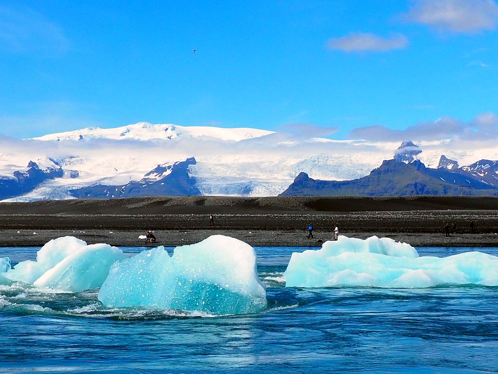
Glacier Lagoon
There are actually two glacier lagoons along this stretch of coast: Fjallsárlón and Jökulsárlón. You’ll pass Fjallsárlón first. It is the smaller and less famous one of the two, which also makes it less crowded.
We went on to Jökulsárlón, usually just referred to as Glacier Lagoon. It was one of the few places where we saw crowds of tourists in Iceland, and it’s not surprising. It’s a fascinating place.
Breiðamerkurjökull Glacier, which feeds into the lagoon, is part of Vatnajökull Glacier, the massive ice cap that is the centerpiece of the Vatnajökull National Park.
Glacier Lagoon formed in the 1930s and has been growing ever since, accelerated by global warming. The glacier moves very gradually downward, and pieces break off of its bottom end. The icebergs float in the lagoon until the meltwater takes them out to sea nearby.
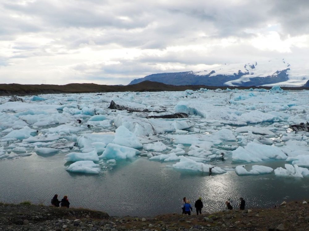
The sight of the lagoon is awe-inspiring: in the background are mountains, with glaciers flowing between them. In the foreground: the lagoon, covered in bluish chunks of ice. Standing there, gazing at that vast view, I felt serene and small.
There are lots of activities on offer near Glacier Lagoon including boat trips, glacier hikes, jeep tours, and ice cave tours. Here is a list of activities to choose from.
The icebergs are bigger below the surface than above. The lagoon is quite shallow, but the channel that empties out to the sea nearby is shallower. The icebergs run aground and, temporarily standing still, they melt in contact with the warmer air. Eventually, they shrink enough to loosen from the riverbed and the river’s flow takes them away to the sea.
I found it somehow mesmerizing to watch the icebergs; they move at a good clip, and some of them stop abruptly, hung up on the riverbed. In some cases this causes them to turn over, exposing the much bluer underside.
Glacier Lagoon: The lagoon is visible on your left. Park in the parking lot on the left just after the route takes you across a bridge. Open all the time. No fee, except for parking: use the Parka app or its website.
Diamond Beach
By the river’s mouth nearby is a black-sand beach that has become known as Diamond Beach. The icebergs, once they hit the ocean, get knocked around by the waves, which melt them more and smooth them. The pieces get washed up on the beach. The way they sparkle in the sun is what gave the beach its name.
To be honest, I didn’t see this at all when I visited. I think it was because the ocean was very calm, so the waves didn’t break up the icebergs. Nevertheless, I enjoyed the sight of Glacier Lagoon and also spent some time trying to capture photos of the many birds that live there.
Diamond Beach: Walk to the beach from the Glacier Lagoon parking lot; follow the path leading next to the river and under the Route 1 bridge to get there. Open all the time. No fee, except for parking: use the Parka app or its website.
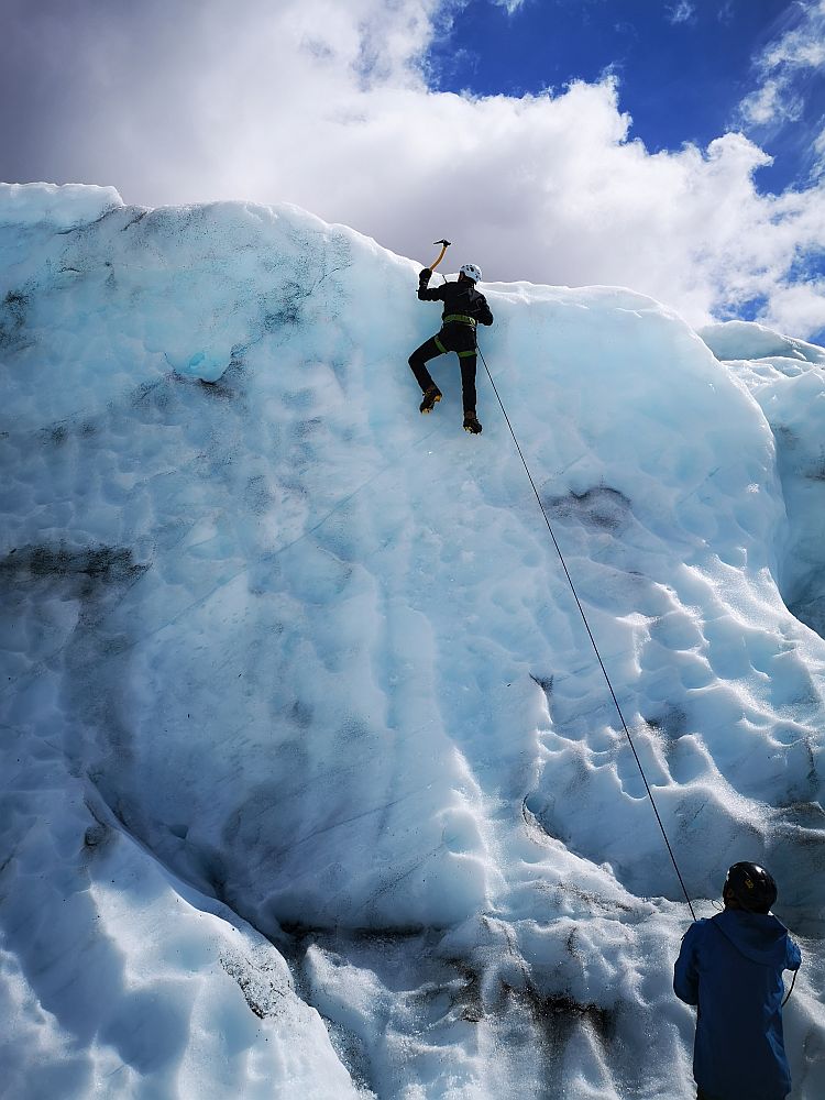
Glacier Hike
Our visit to Glacier Lagoon didn’t go quite as I had planned. I had booked to take a boat tour of the lagoon, but it was canceled. Apparently the lagoon was just too full of icebergs for the tour to happen.
Albert, though, was booked to do a five-hour glacier hike with Troll Expeditions inside Vatnajökull National Park, and that was a great success. You can read his description of the hike at this link.
Viking village film set
Apparently this film set just south of Höfn was built in 2010 for an Icelandic film that never ended up getting made. You can pay the landowner a fee to explore it. We didn’t bother because it’s, well, fake, but the landscape around it is said to be very pretty.
Viking village film set: About 5 kilometers past Höfn on route 1, turn right onto the dirt road toward Stokksnes. Turn left at the Viking Cafe. Admission: 1,100 ISK, children under 16 free.
Day 8: Eastern Iceland
Accommodations for 1 night: Seyðisfjörður or Egilsstaðir
At the end of today’s drive, you could stay at Seyðisfjörður or Egilsstaðir. Seyðisfjörður is further off Route 1, but it’s pretty, while Egilsstaðir is a larger town, right on the route. Either would be fine for this one-night stay.
Accommodations in Seyðisfjörður or Egilsstaðir (Zoom out and look east to see Seyðisfjörður accommodations):
Driving
The eastern end of Iceland is sparsely settled and the sights are fewer and farther between. That means that today will mostly be a driving day. Stop whenever it suits you and the weather allows.
It’s a stark, dramatic coastline, and the road allows lots of big views of mountains on one side, sea on the other. The weather, though, wasn’t great when we drove it, and the low cloud obscured the tops of the mountains for us.
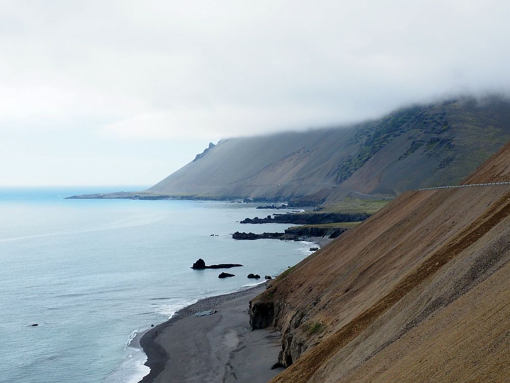
The route has occasional parking areas, and we stopped to walk on small beaches or just to stand along the road and do some birdwatching. Mostly we saw ducks, often in large groups, and seagulls, which nest in the cliffs.
Djúpavogskörin Natural Geothermal Pool
If you want a soak in a natural geothermically-heated spring, stop at Djúpavogskörin Natural Geothermal Pool. It’s a rectangular tub with a wooden platform around it, just a hundred meters from Route 1. There are no facilities or changing room, so be ready for a quick change in the open, though you won’t be visible from the road.
Djúpavogskörin Natural Geothermal Pool: On your right just before the little town of Djúpavogur. No facilities or changing rooms. Open all the time. No fee.
Icelandic Wartime Museum
The Icelandic Wartime Museum illustrates a part of World War II history that I’d never considered before: Iceland’s importance for shipping.
Iceland was ruled by Denmark as the war began. While Iceland and Denmark were officially neutral at the start of the war, Iceland’s location meant it was of vital importance. Even before the US joined the war, ships passed through here to supply the UK with war materials under the Lend-Lease Act. German merchant ships also used Iceland’s waters.
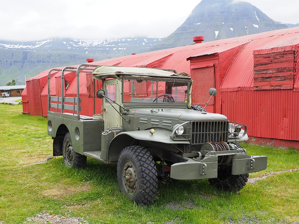
Germany occupied Denmark in April 1940 and had every intention to do the same with Iceland. This led the British to invade Iceland in May 1940 in order to prevent it from falling under Germany’s control, and to keep Iceland as a stopover point for shipping. A year later, the British handed over the island to the US. Iceland declared independence from Denmark in 1944 and stayed officially neutral, but continued to cooperate with the US military, who stayed until the war’s end.
The Icelandic Wartime Museum shows artifacts from this period as well as mock-ups of, for example, a wartime movie theater in a Quonset hut, a wartime café, a barracks, and so on. You’ll see uniforms from US soldiers, a collection of records, jeeps, weapons and so on. Films from the period tell the stories involving how the military presence affected the locals.
Outside of the museum are several Quonset huts painted bright red. Originally barracks, built by the Americans, they were not open for viewing when we visited. After seeing this museum, I noticed as we continued our journey that many farms all over Iceland have Quonset huts that they use as barns. I don’t know if these are left over from the war, or later purchases.
The Icelandic Wartime Museum: Heiðarvegur 37 in Reyðarfjörður. Open daily in June-August 13:00-17:00. Website.
Seyðisfjörður
If World War II history doesn’t interest you, go see Seyðisfjörður instead. This picturesque little fishing village has a center of original wood houses painted in bright colors and a particularly lovely church.
Days 9-10: Myvatn and Húsavík
On Day 9, drive in the morning, then see Dettifoss, Selfoss, Viti Crater, Myvatn Lake and Myvatn Nature Baths before reaching your accommodations. Spend Day 10 in Húsavík.
Accommodation for 2 nights: Lake Myvatn or Húsavík
Staying in Húsavík would mean more driving on Day 9 but would make a more relaxed Day 10 in Húsavík. On the other hand, staying in Lake Myvatn would position you on Day 11 to get right back onto Route 1 first thing in the morning. Or you could compromise and choose accommodations somewhere between the two.
Find accommodations in Húsavík or near Lake Myvatn.
We stayed at Skútustadir Guesthouse, right across the road from Lake Myvatn. It’s a cross between a hotel and a hostel, with a large hostel-style kitchen and dining area to share. This isn’t a complaint; it was good to have so much room for cooking. We stayed in a row of rooms that looked on the outside like a temporary building, but felt like a comfortable and clean hotel room inside. The bathroom was simple but clean. Breakfast is included and was excellent, with locally-smoked fish and homemade jams. The guesthouse is a family-run business and includes an ice cream place on-site that uses locally-sourced milk.
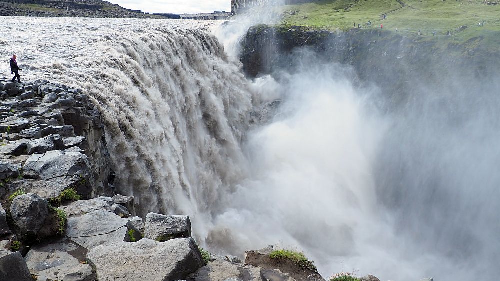
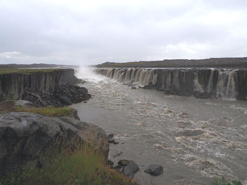
Dettifoss and Selfoss
Dettifoss and Selfoss are waterfalls in a single river and they’re both absolutely glorious. You can read about them in my article about waterfalls in Iceland.
Viti Crater
Viti Crater is, like Kerið, a result of volcanic activity, but is much younger, having formed in 1724. It’s an explosion crater, a result of a huge eruption that went on for five years. Apparently the contents of this crater kept bubbling for more than a hundred years after that.
Now it is a bare gravel cone with incredibly blue water at the bottom. You can walk along the rim to see it from all sides. Even in the middle of the summer, almost nothing grows on it, and the scenery looking out from the cone shows a lot of dead rock-strewn ground: very much a moonscape.
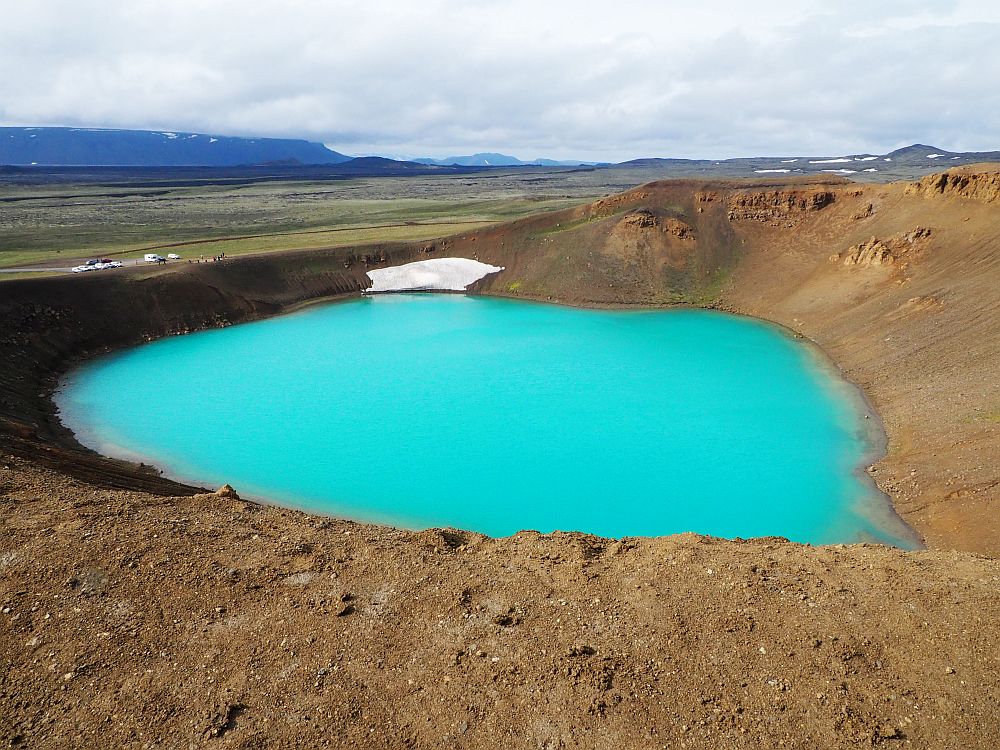
Rumor has it that you can swim in Viti Crater, with a natural temperature in the high 20s celsius (about 80 fahrenheit).
The road to Viti is nicely paved, rising in elevation to about 1000 meters (3500 feet) above sea level. You’ll notice, on the drive up, plumes of steam here and there, testifying to the geothermal activity still going on underground.
Viti Crater: Six kilometers east of Myvatn on Route 1, turn left and keep driving past the power plant. Always open, no admission charge.
Lake Myvatn
Since we stayed right next to Lake Myvatn, we mostly saw it in glimpses as we passed by on the road, though it was a good place for a bit of birdwatching too. This volcanic lake and the wetlands around it are home to many water birds, so if you are into birdwatching, plan some walks around the lake, binoculars in hand. Make sure to take some insect repellent along too; there are lots of midges.
Lake Myvatn: The paths are always open. No fee.
Sigurgeir’s Bird Museum
We didn’t visit this museum on Lake Myvatn, but it sounds like it’s primarily a collection of stuffed birds and their eggs. It might be worth a stop if you want to be able to identify various Icelandic bird species.
Sigurgeir’s Bird Museum: Ytri-Neslönd, 660 Mývatn. On Route 1, it’ll be on your right as you pass the lake on your right. Open daily September-May 14:00-16:00 and June-August 12:00-17:00. Admission: adult 2,400 ISK; children 7-14 1,400 ISK. Website.
Earth Lagoon Myvatn (formerly called Myvatn Nature Baths)
A great end to our day was a soak in a hot spring bath at Earth Lagoon: enjoying the sulphurous water with a drink in our hands, looking at the dramatic Myvatn landscape in the distance. The facility is currently closed and being renovated. It should reopen in April 2026. You can read more detail about Myvatn in my hot springs article.
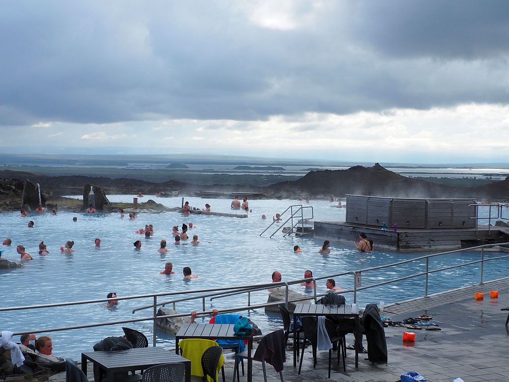
Earth Lagoon Myvatn: Jarðbaðshólar, Myvatn. Open daily 12:00-22:00. Admission prices before the renovation started at 7,900 ISK; children 13-15 3,900 ISK; younger children free. Tickets.
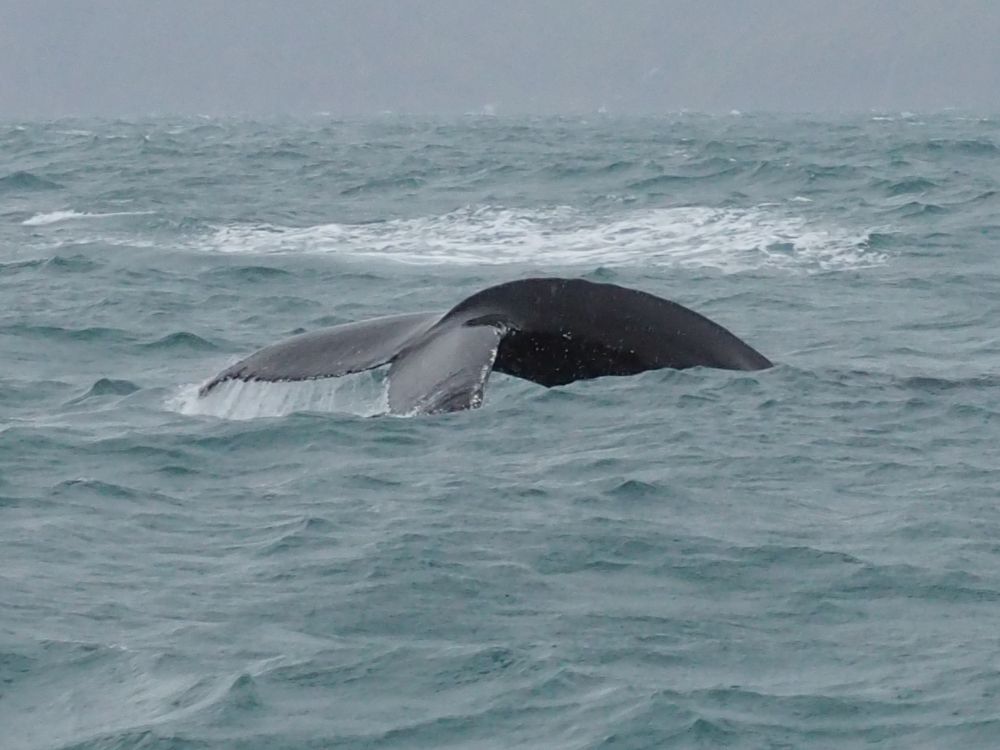
Whale watching
Day 10 was the day I’d been looking forward to the most: we’d booked a whale-watching trip from Húsavík, on the north coast of Iceland. The trip turned out to be quite a bit less idyllic than I imagined. You can read the woeful, yet triumphant, story here.
Book your whale-watching tour ahead of time. Here is the tour we took, which I’d recommend, assuming the weather is better than when we went. They meet in Husavik harbor.
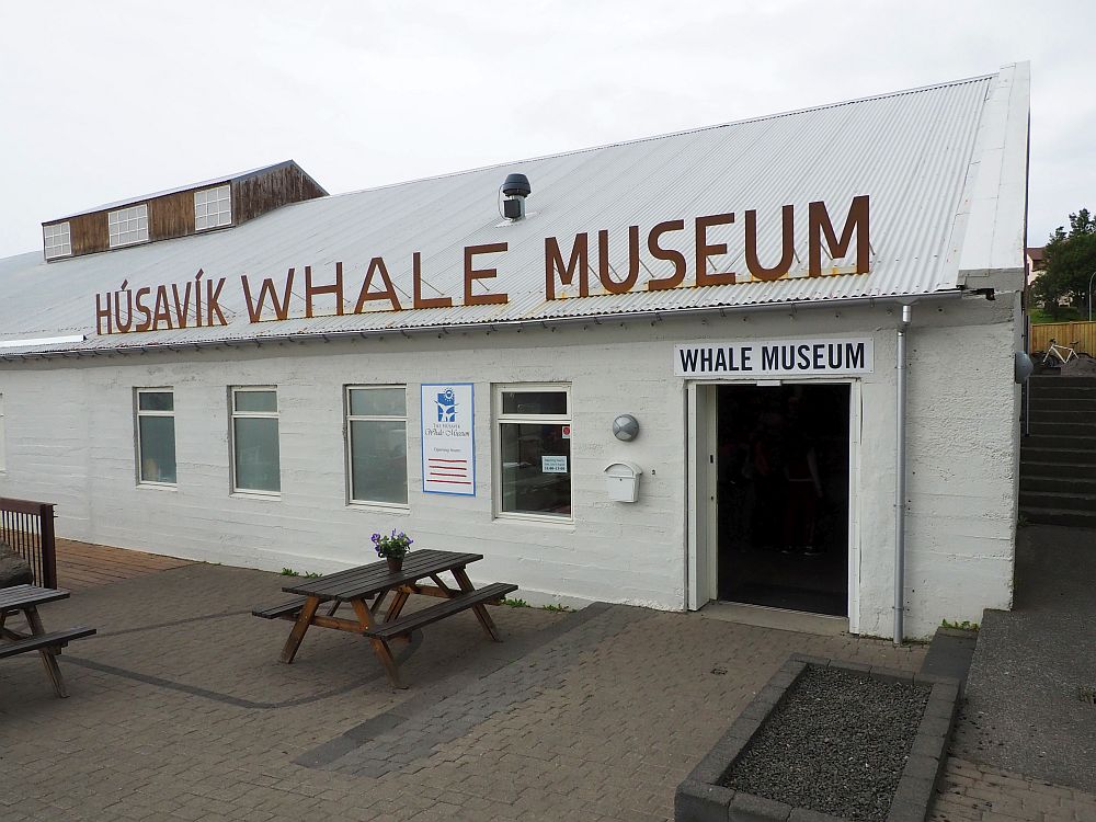
Húsavík Whale Museum
Before the whale-watching trip, we visited the Húsavík Whale Museum right next to the harbor. Here we learned about lots of different species of whales that live in or at least pass through Iceland’s waters.
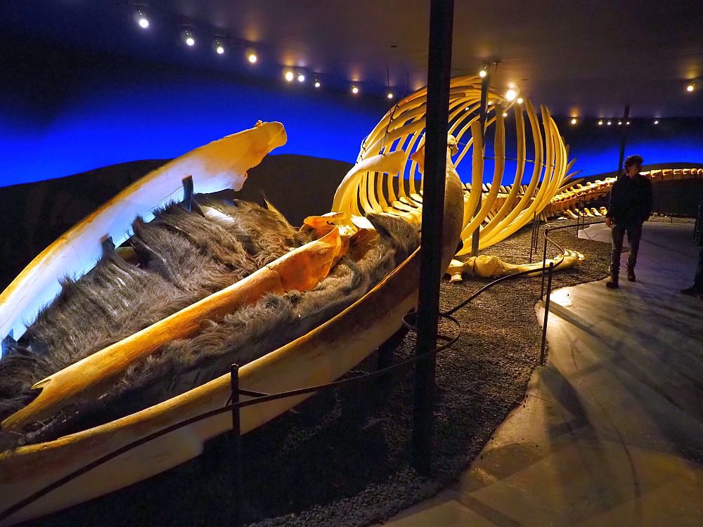
The main hall is long and narrow, and the exhibits there are rather dry: signs on the wall include an image and information on each whale type. It gets better in the rest of the museum, though.
The most interesting part is upstairs above the main hall: a series of whale skeletons hang there along both sides of a narrow catwalk, with accompanying illustrations and information in Icelandic, English and German. On the ground floor is a skeleton of a blue whale, astonishing in terms of sheer size.
The skeletons on display either washed up on the shore of Iceland somewhere or got tangled in a fishing net and drowned. Either way, the museum’s staff takes the body and strips the meat off the bone for display.
Videos illustrate whales – a mesmerizing one showing two whales in the sea, including the sounds they make – and whaling – a rather gruesome film showing the whole process of taking a dead whale ashore and cutting the blubber and meat off of it, filmed, I’d guess, in the 1960s or 70s. I learned that whaling is still, to a limited extent, practiced in Iceland.
One section gives information about the local white-beaked dolphin and orcas, which are also a type a dolphin. Another looks at whales in the Icelandic sagas and other historical mentions of whales. One room displays artworks portraying whales. There’s also a whale-themed playroom to keep the kids happy.
Húsavík Whale Museum: Hafnarstétt 1, Húsavík, Iceland. Open daily April-October 9:00-18:00 and November-March 10:00-16:00. Admission: 2,500 ISK, children under 17 free. Tickets.
Húsavík town
We didn’t spend enough time in Húsavík to explore the town properly. Some prettily-restored buildings at the harborside house restaurants and such, and the harbor itself is home to an array of fishing and whale-watching boats.
The wooden church in Húsavík dates to 1907. It is distinctly more ornate than other churches we passed in similarly small towns. Most of them are simple rectangles with a peaked roof and a plain steeple. This one is a more complicated construction with more decorative elements, both inside and out.
Day 11: Across Northern Iceland
This day will involve a lot of driving, especially if you try to see all the sights. You might need to skip some of the ones that are further off the main road, out on the coast.
Accommmodations for 1 night: Varmahlið
Karuna Guesthouse, just north of Varmahlið, is where we stayed. It has big views over a valley with mountains beyond it. The room we had was tastefully decorated and we shared two bathrooms with several other rooms. The kitchen is also shared and well-supplied; breakfast isn’t served, but breakfast supplies are. There was plenty for us to eat, clearly marked. A large hot tub is open to guests as well: a great spot to take in that big view.
For other options in or near Varmahlið, use this map:
Goðafoss waterfall
Goðafoss waterfall is right on the ring road and, while it’s not as overwhelmingly big as some, it’s very pretty, the way it tumbles over a crescent-shaped rocky shelf. You can read more about it in my post on the waterfalls of Iceland.
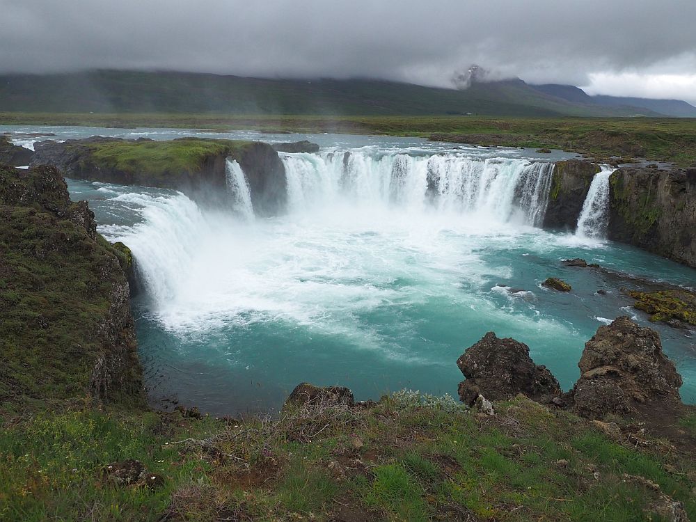
Goðafoss: Open all the time. No fee. Free parking.
Toll tunnel
About halfway between Goðafoss and our next stop, Laufás, the ring road passes through Vadlaheidargong Tunnel, which is 7.5 kilometers (4.7 miles) long. I point this out because it is Iceland’s only toll road. You can pay online up to 24 hours before passing through it or up to three hours after passing through it. The price is 2,152 ISK. Don’t forget to pay, or your rental company will charge a hefty fee on top of the toll charge.
Your other option is to take the longer and more scenic route, but only if the weather is good! Take a right off the ring road onto route 84, then go straight when it meets 83 as you reach the coastline. This adds about 16 kilometers (10 miles) to the journey.
Akureyri Museum
We didn’t stop at the Akureyri Museum, but it sounds like it would be interesting. Located in the old part of the town of Akureyri, the museum is made up of three parts. You can view a very simple wooden church dating to 1846; Nonni’s House, also a simple brown wood structure from the 1840s; and a museum that addresses local history and particularly local Christmas traditions. It also has a collection of antique maps of Iceland going back as far as 1547. The museum organizes a medieval festival in mid-July.
Akureyri Museum: Aðalstræti 58, Akureyri. The museum, Nonni’s House, and the Industrial Museum are all open daily June-September 11:00-17:00 and daily 13:00-16:00 in the winter. Admission: 2,000 ISK for all three museums, children free. A 24-hour pass (2,600 ISK) is available for these three museums plus Laufas Turf Farmhouse. Website.
The Icelandic Aviation Museum
This is another one we didn’t get to see, but it sounds like fun. Housed in a hangar at Akureyri Airport, it holds a collection of models and actual aircraft to illustrate the history of aviation in Iceland.
Icelandic Aviation Museum: Akureyrarflugvelli (Akureryri Airport), Akureyri. Open mid-September to mid-May only on Saturdays 13:00-16:00; mid-May to mid-September open daily 11:00-17:00. Admission: 1,800 ISK; children under 18 free. Tickets.
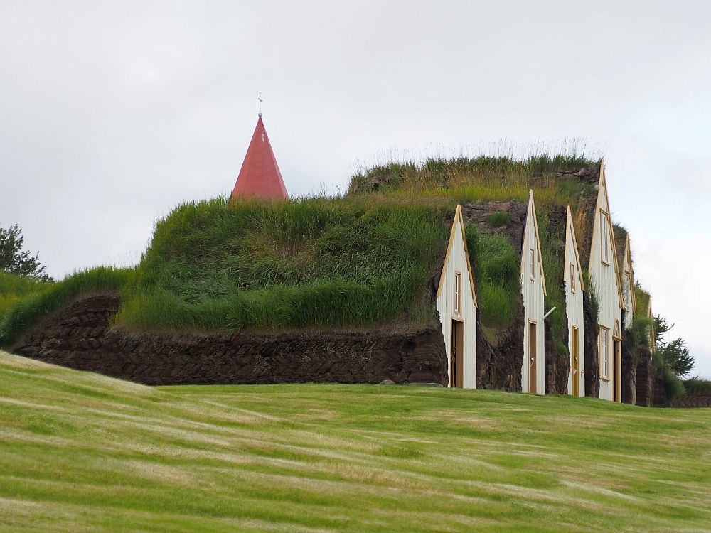
Laufás Turf Farmhouse
Laufás is a farmhouse made of turf that is now a museum. It is incredibly picturesque, with its neat rowhouse-like front and grassy roof and sides. It sits next to a pretty wooden church. The inside is furnished, giving an idea of what life was like on a prosperous Icelandic farm.
You can read more about Laufás (and Glaumbaer, listed below on Day 12) in my article Icelandic turf houses: Laufas, Glaumbaer and others.
Laufás Turf Farmhouse: Laufás. Open daily June 1-mid-September 11:00-17:00. Admission: 2,000 ISK; children free. A 24-hour pass (2,600 ISK; free for children under 18) is available that covers this museum as well as the Akureyri group of museums. Website.
The Herring Era Museum
We didn’t get there, but from Laufás you could drive all the way north to the tip of the peninsula to Siglufjörður, a pretty fishing village that used to be an important port for the herring industry. The Herring Era Museum tells, inside five former herring processing buildings, all about how herring was salted, dried and processed and about the people who worked and lived there. The museum includes 11 historical fishing boats and a boatyard.
The Herring Era Museum: Siglufjörður. Open June-August 10:00-17:00; May and September 13:00-17:00. Admission: 2,400 ISK; children under 16 free. Website.
Hofsós Pool
While it isn’t a natural pool like some of the others I’ve mentioned, we decided to go to Hofsós because my husband’s sister and her wife spoke so enthusiastically about it. You can read about it in my post about hot springs.
Hofsós Pool: Route 76, Hofsós. Open October-May Monday-Friday 7:00-13.00 and 17:00-20:00 and Saturday-Sunday 11:00-16:00. In June-September open Monday-Friday 7:00-20:00 and Saturday-Sunday 10:00-20:00. Admission: 1,300 ISK; children 7-17 415 ISK; under 7 free. Website.
Icelandic Emigration Center
In the same town as the pool, you’ll find the Icelandic Emigration Center (Vesturfararsetrið). We didn’t get there, but apparently it focuses on emigration to North America from Iceland. It includes exhibits about the emigrants and has a genealogical service as well. You should certainly go there if you have Icelandic ancestry.
Icelandic Emigration Center: Vesturfarasetrið, Hofsós. Open daily June-August 11:00-18:00. Otherwise, by appointment only. Website.
The oldest church in Iceland
This tiny church, properly called Grafarkirkja, sits in the middle of a flat grassy field in a valley flanked by mountains. It’s hard to spot it from a distance, even once you’ve parked, except for the single small tree next to it.
It certainly doesn’t seem to be visited often, either by worshippers or tourists. The path we walked on was unmaintained and narrow in places, with tall grass growing along it.
There’s not much to it. Made of turf with wooden end walls and interior, it dates to the late 17th century. The grass-covered roof and the turf wall around its circular cemetery make it seem one with the surrounding environment. Abandoned in the 18th century, it was finally rebuilt in 1953 by the National Museum of Iceland. I suppose that, if it’s not maintained, a turf construction slowly disintegrates.
Grafarkirkja: From the junction of route 76 and the smaller route 77, watch your odometer. 3.2 kilometers south of that junction, turn left onto a dirt road and then immediately right onto a dirt road that parallels route 76. Park there and walk on the marked path across the field to the church. Closed, but you can peek in the window. No fee.
Days 12-14: The Westfjords
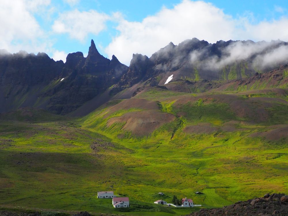
The reason this 3-week Iceland itinerary is different from the one we actually did is that we didn’t get nearly enough time in the Westfjords. The scenery here is just phenomenal, so I’ve adjusted the plan to give you more time there.
After you spend Day 12 driving west, with a few stops on the way, I’ve planned two full days in the Westfjords. It will involve a lot of driving. The fjords are beautiful but the driving is slow because the roads follow the contours of the coast.
I’ve placed the sights below into three groups, but all of them will involve a lot of driving in any case, so you might have to make some choices. The landscape and the fjords are just breathtaking, so stop often to take in the views!
Be careful, though, never to stop in the road. There are frequent, marked places to pull over.
First, though, there are a few things to see on the way: Glaumbaer turf farmhouse and the church in Víðimýra are quite near to Varmahlið.
Accommodations for 3 nights: Westfjords
The key here, I think, is to establish a home base somewhere in the middle of the Westfjords and make trips from there on days 13 and 14.
We stayed near Hólmavik, but it isn’t very central. You might be able to see more fjords if you choose something further west. Use the map below to choose a central location, zooming in to see the accommodation markers.
On the way to the Westfjords: Glaumbaer, Víðimýrarkirkja and Hvítserkur
Glaumbaer
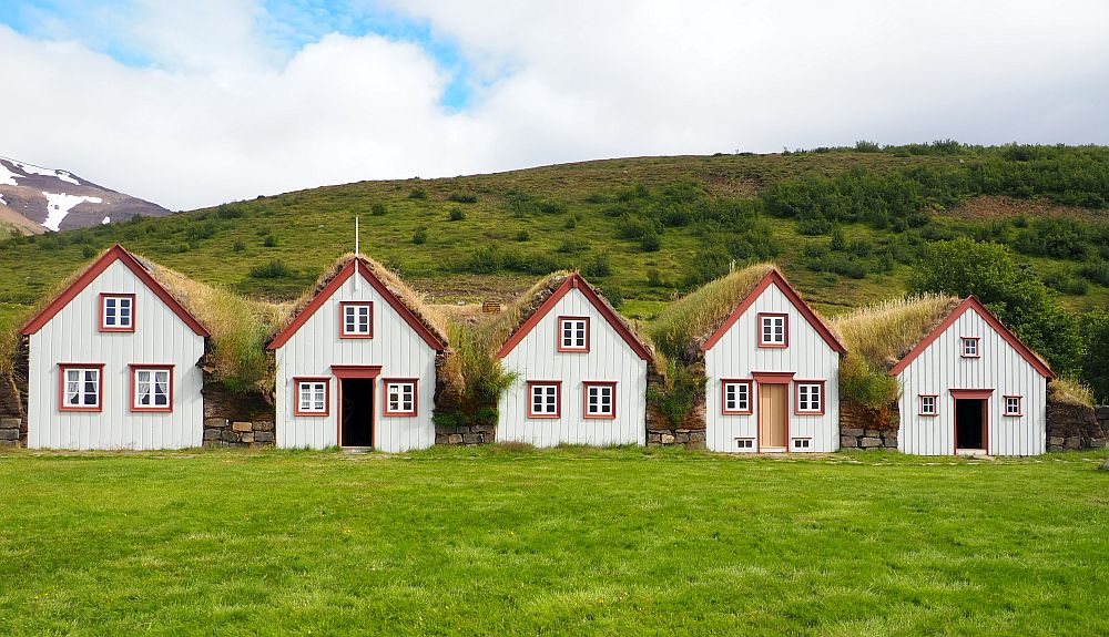
Glaumbaer turf farmhouse is much like Laufás, with the row of turf-covered peaked roofs and a church next door, but it’s somewhat bigger. Like Laufás, the rooms are furnished to period. It also has a couple of later wooden houses nearby to see how Icelandic architecture evolved away from turf construction. See my article on Icelandic turf houses.
Glaumbaer turf farmhouse: Varmahlið. Open daily 10:00-18:00 from mid-May to mid-September. Mid-September to mid-October and April until mid-May open Monday-Friday 10:00-16:00. Closed mid-October to end of March (but ring the doorbell of the ticket office and if there’s someone there they might let you in). Admission: 2,200 ISK; children 0-17 free. A combined ticket with Víðimýri Turf Church is 2,600 ISK. Website.
Víðimýrarkirkja
How did we miss this? A much shorter drive from our accommodation than Grafarkirkja, the turf church in Víðimýra is considered possibly the prettiest of the turf churches. Its black front with brightly painted door, window and entrance gate is picture-perfect. It dates to 1834.
Víðimýrarkirkja: Assuming you’re still driving the ring road counter-clockwise, two kilometers after the junction of route 1 and route 75, turn left onto a dirt road and it’s less than a kilometer further. Open June-August only; Tuesday-Sunday 12:00-17:00. Admission: 1,100 ISK; children 0-17 free. A combined ticket with Glaumbaer Turf Farmhouseis 2,600 ISK. Website.
Hvítserkur
On the way to the Westfjords we made a detour to see Hvítserkur, a well-known rock formation off a rocky beach. A small waterfall trickles down a hill into the sea right at this point. The rock formation stands on three narrow bases and, in the fierce wind that day, I wondered how it stayed upright. In any case, it was a prime location to spot sea birds.
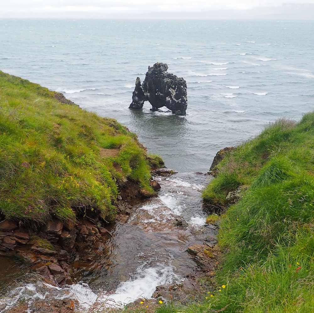
Hvítserkur: Take a right from route 1 onto route 717, which then joins route 711 north along the coast. Hvítserkur is on the right.
Group 1: Hólmavik, the Museum of Icelandic Sorcery, The Sorcerer’s Cottage, and the Djúpavík Herring Factory
Hólmavik
Hólmavik is a picturesque fishing village that’s worth a stroll.
The Museum of Icelandic Sorcery and Witchcraft
This museum is why we went to Hólmavik. My husband was less enthusiastic than I was, but I hoped for a museum about the general history of witchcraft and about magic.
That’s not really what it was. Instead, it was much more narrowly focused, addressing a specific series of 21 witch trials that happened in Iceland in the 17th century. When people were accused of witchcraft, they needed other members of the community to vouch for them. People who were not well-liked couldn’t get anyone to vouch for them. Even people using witchcraft for good, like one who used a spell to try to protect his sheep from being attacked by Arctic foxes, were tried.

Interestingly, these witch trials involved male witches almost exclusively, unlike the witch trials that happened that same century in other places, particularly the famous ones in Salem, Massachusetts.
The problem with this museum is that it doesn’t seem to have many historical artifacts to show. Instead, examples of various items used in spells in Iceland are shown, along with references to the documentation about these particular alleged witches. Staves carved with spells, grimoires and other tools of witchcraft are on display.
The most shocking of these objects is – or appears to be – a skin removed from a man: legs and genitals. I’ll spare you the photo. It wasn’t clear to me whether it was real or just meant to look that way. It goes with a detailed story of how such “necropants” could be used to become wealthy.
The Museum of Icelandic Sorcery and Witchcraft: Höfðagata 8-10, Hólmavik, in the same building as Galdur Restaurant. Open summers (May 15-end of September) daily 10:00-18:00; winters daily 12:00-18:00. Admission: 1,400 ISK; children up to 14 free. Website.
Sorcerer’s Cottage
The museum also operates a “sorcerer’s cottage,” a turf house further up the coast, but it was closed for renovation when we visited. I wanted to see it because it apparently is more representative than turf houses like Laufas and Glaumbaer of how the poorer Icelanders lived.
Sorcerer’s Cottage: Route 643, 25 km north of Hólmavik. Part of the Museum of Icelandic Sorcery and Witchcraft. Admission is free.
Djúpavík Herring Factory
This museum inside a huge abandoned herring factory building looks at the herring industry that once thrived here … but only for 20 years. The building where the female workers used to live has been restored to serve as a hotel.
Djúpavík Herring Factory: Djúpavík 524 Árneshreppur. Daily tours of the old factory at 10:00: 3,800 ISK each, minimum 2 people. Website.
Group 2: Dynjandi waterfall and Reykjafjarðarlaug hot spring
Dynjandi waterfall
While Dynjandi is not the biggest or most powerful waterfall, it descends beautifully in a neat series of steps, like wavy long hair.
Dynjandi waterfall: Near the junction of route 60 and route 626. Open all the time. No fee.
Reykjafjarðarlaug swimming pool and hot spring
A “wild” hot spring next to a swimming pool, with only a small shed as a changing room. It’s the kind of middle-of-nowhere place you’re likely to have all to yourself. Without a four-wheel drive vehicle, it’s best not to attempt it outside of summer because of the poor state of the road.
Reykjafjarðarlaug swimming pool and hot spring: Route 63, out near the tip of the bottom-most finger of the Westfjords. Open all year 24 hours/day. No fee.
Group 3: Vatnsfjörður church and Ísafjörður
I’ve grouped these two together, but they are not near each other.
Vatnsfjörður
We stopped at a few places that were marked as sites of interest, mostly pretty little churches. One of these, Vatnsfjörður, was a prosperous farm from the 12th to the 17th century. Excavations show an even earlier Viking farm on the site, though those excavations were so overgrown when we visited that we had trouble even spotting them.
The church that stands there now dates only to 1912 and has a circular graveyard, a tradition that goes back to Iceland’s pre-Christian era.
Vatnsfjörður: Route 61 at the tip of the peninsula. The church is usually closed, but the site is open all the time. No fee.
Ísafjörður
I’ve heard good things about Ísafjörður, where a group of 18th-century buildings house a heritage museum.
Ísafjörður: Neðstikaupstaður, Ísafjörður. Open mid-May to the end of August daily 9:00-17:00; first half of September 9:00-15:00; and second half of September 11:00-15:00. Closed for winter. Admission: 1,750 ISK; children free. Website.
Subscribe to my once-a-month newsletter to receive my pared-down, just-the-essentials 3-week Iceland itinerary! It’s suitable for printing out or you can download it to your phone. Use the form below:
Days 15-16: West Iceland
Day 15 is mostly a driving day out to the tip of West Iceland, properly called the Snæfellsnes peninsula, but with a few possible stops. The scenery should keep you entertained, because it’s stunning and very varied.
Green, tidy-looking farmland dotted with white plastic-wrapped bales of hay, lava fields strewn with black rocks, stark craggy mountains, picturesque churches overlooking the sea … the views constantly change.
On Day 16 you can see the sights in or near Snaefellsjökull National Park.
Accommodations for 2 nights: Snaefellsjökull National Park
We stayed at Biker’s Paradise in Olafsvik, a house that is now used as a guesthouse. The owners live on the lower level and pop in now and then to make sure the guests are all right. Our room was simple and clean and we liked that we could hear the sound of the waves outside the room. The décor of the place is not to my tastes, but the sitting area and kitchen were comfortable, clean and well-equipped.
The rooms share two bathrooms, only one of which has a shower, so I imagine that when it’s full you might have to wait. The same goes for the kitchen, which got a bit crowded even with only three of the rooms being used when we were there.
Other accommodations near Olafsvik and Snaefellsjökull National Park (Zoom out to see the whole peninsula. I don’t think there are any accommodations within the park limits):
Grábrók volcano
This 170-meter-high volcanic crater isn’t on the way to or from anywhere in this 3-week Iceland itinerary. It’s right on route 1, the ring road, but it’s the part of the ring road you’ll miss if you go to West Iceland. I’m listing it here in case volcanos are of particular interest to you. You can climb to the top along a trail, with great views of the surrounding landscape as your reward.
Grábrók volcano: Right next to route 1, north of Borgarnes. Open all the time. No fee.
Bjarnarhöfn Shark Museum
We expected to learn all about sharks at this little museum, but it turned out to be only about one species – Greenland shark – and how its meat is processed for consumption.
Traditionally, Greenland sharks were hunted for their meat. These days, with much less demand, the few families that still process Greenland shark meat only use by-catch sharks: ones that get caught up in fishing nets.
The problem with Greenland shark meat, though, is that it is poisonous. It has too much urea and trimethlylamine oxide, so has to be processed to make it safe. (This is one of those cases where I wonder who first figured this out, and how many people died in the process!)
In the old days, the shark was first gutted and then buried in gravelly sand with heavy stones on top to press the liquid out. It would ferment in the ground for 6-12 weeks.
Next, it was dug up and the meat was cut into chunks, then hung up outside under a roof to dry for several months.
That’s it. No cooking, just fermenting and drying. Nowadays, the meat isn’t buried, but is packed and pressed in plastic boxes. It still gets hung up for drying though.
This little museum, then, tells about this process. The man who told us about it is from one of the remaining shark-processing families. The fishing (sharking?) boat filling one end of the museum’s single large room was his grandfather’s.
After we heard an explanation of the whole process, we got to taste a piece. It had a very strong flavor, but wasn’t nearly as putrid as I feared: just strongly fishy-tasting, with an ammonia aftertaste. It wasn’t pleasant, but it wasn’t dire either.
Shark Museum: Bjarnarhöfn in Stykkishólmur. Open in the summer 10:00-17:00. Admission: 2,000 ISK, children up to 15 free. Shark meat tasting is included. Website.
Kirkjufellsfoss waterfall
Compared to many waterfalls we visited on this 3-week Iceland itinerary, Kirkjufellsfoss is rather underwhelming. That’s not to say it’s not pretty, because it is. And it’s very photogenic with the conical Mt. Kirkjufell right beside it. Read more about it in my article about waterfalls in Iceland.
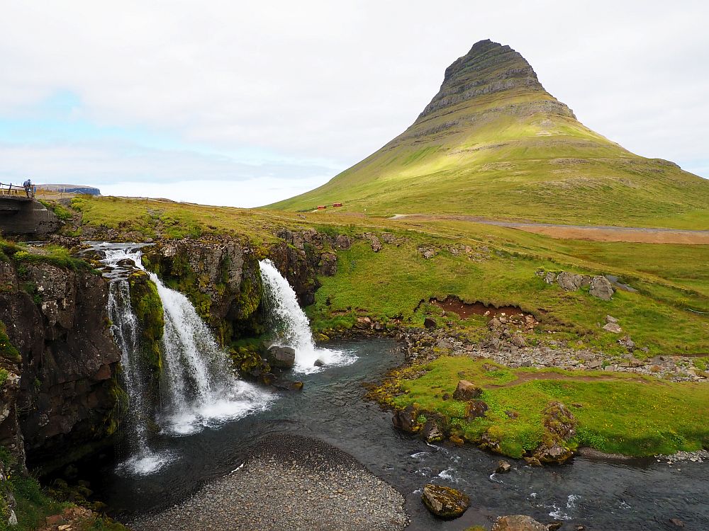
Kirkjufellsfoss: Route 54 along the north coast of West Iceland. Open all the time. No fee.
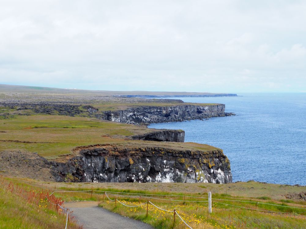
Snaefellsjökull National Park
Snaefellsjökull National Park extends across the tip of the peninsula with a raw, cliff-edged coastline. Several of the following places are inside the park while the others are nearby.
The Maritime Museum Hellissandur
The Maritime Museum in Hellissandur is more about fishing history in the area than anything else.
Because this museum has a reconstruction of a fishermen’s cottage made out of turf, I included it in my article about turf houses, so you can read more about it there. It’s worth visiting mostly for the turf house, not so much for the exhibits inside, unless you’re into natural history and/or Icelandic fishing history.
Hellissandur Maritime Museum: Sandahraun 7, Hellissandur. Route 574 west of Olafsvik. Generally open summers, Tuesday-Sunday 11:00-17:00, but it is unclear if it’ll open again in 2026. Admission: 1,300 ISK, though this has likely gone up; children 0-16 free. Facebook page.
Svörtuloft Lighthouse
Svörtuloft Lighthouse, dating to 1931, is inside Snaefellsjokull National Park. Painted bright orange, it makes quite an impression.
Svörtuloft Lighthouse: Take the dirt road off of route 574, past Skardsvik beach (white sand) to the lighthouse. Be cautious if you don’t have a four-wheel drive car. Open all year. No fee.
Saxhóll Crater
Inside Snaefellsjokull National Park, we noticed a small mountain standing alone in a relatively flat lava-covered landscape. It was obviously a volcanic cone, and when we neared it and saw that it could be climbed, we decided to stop and see.
Saxhóll is a collapsed crater, formed about 3000 years ago. It’s mostly dark lava sand and rock, with some moss cover in places.The cone is only about 100 meters high, and a metal stairway climbs gently around about a quarter of the crater to reach the top. The crater holds no water or lava, so it doesn’t impress like Viti or Kerið. However, the view from up there is wonderful: craggy snow-tipped mountains in the distance on one side, the sea in the distance in the other direction, and a flat, lava-strewn landscape all around, with another crater rising from it not far away.
Saxhóll Crater: Take the turnoff from route 574. Gradual stairs to the top. Open all the time. No fee.
Vatnshellir Lava Tube
All that is visible when you drive to Vatnshellir inside the park is a very small wood and glass building, standing by itself in the middle of a moon-like landscape covered in lava rocks.
Checking in at the desk, we were issued a plastic helmet and a flashlight on a cord so we could hang it around our necks. The guide started right outside the little building telling us to wear gloves if we had them so we wouldn’t hurt our hands if we had to grab onto any rocks. He checked to make sure we were wearing appropriate shoes as well. Warm clothing is also recommended because it is cold in the tube.
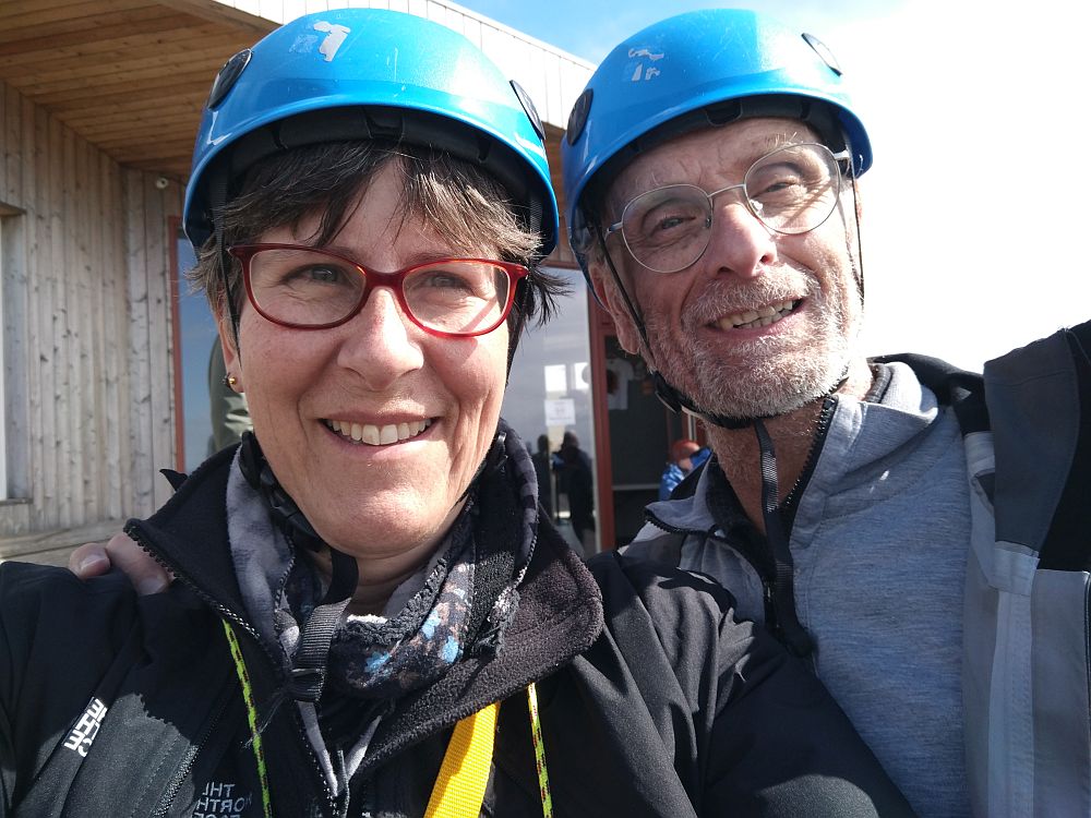
Before we descended into the lava tube, the guide explained how lava tubes form. When lava flows from a volcano, which can go on for years, the cold air and rain contacting the lava causes it to harden on the outside, forming a crust. As long as the lava keeps flowing, it moves under that crust downhill toward the sea. When the eruption dies down, the remaining lava flows out and leaves the tube in place. If a piece of the tube collapses, the tube opens up. That’s what happened about 8000 years ago at Vatnshellir.
The guide led us down a stone stairway, then down a long metal spiral staircase. To appeal to the children in the group of about 20 people, he told us a story at the bottom about trolls who meet in the tunnel every year, and how if we disturbed anything about the tunnel, the trolls would come and eat us.
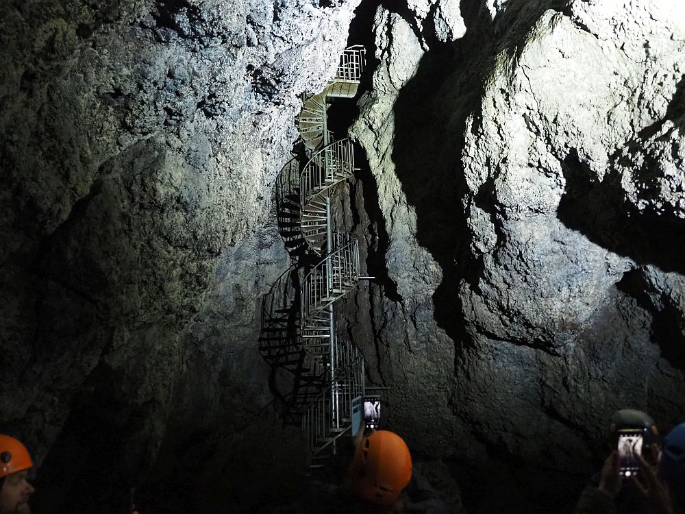
Inside the tube, the guide pointed out the striations along the side walls, showing the different levels where the lava had flowed through. Different colors in the rock indicate different minerals mixed in. Spots that shine are bits of mica. We walked a short way down the tunnel along a rope that marked the way. The floor was very uneven and strewn with loose rocks. I stumbled several times.
At one point, the guide stopped and told us all to turn off our flashlights in order to see what real darkness looks like. Waiting a few minutes, standing still in the true pitch darkness, we allowed our eyes to adjust. It was disconcerting to have my eyes wide open and see absolutely nothing. When he turned on his extra-bright flashlight, for a moment we could see more colors in the rock.
While it was interesting, this tour doesn’t compare with tours of, for example, caverns carved by water, where the stalactites and stalagmites can be quite beautiful. This wasn’t.
We were lucky to get on a tour of Vatnshellir Lava Cave, arriving earlier and booking it for later the same day. Apparently it’s normally necessary to book these tours well ahead of time.
Vatnshellir Lava Cave: Vatnshellir Cave, Road 574, Snæfellsbær. Admission: 5,900 ISK; children 12-17 2,600 ISK; under 12 free. Tickets.
Arnarstapi-Hellnar trail
Arnarstapi is a small village on the southern coast of the West Iceland peninsula, outside the park boundaries. With a tiny fishing harbor and an incredibly picturesque house posed above it, it gets a lot of tourists in the summertime.
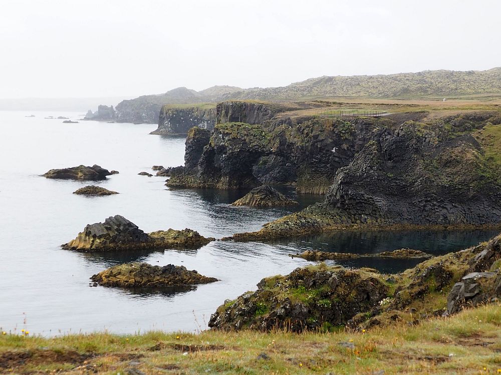
A trail extends from Arnarstapi along the coast to the next village, Hellnar. It follows the cliff edge, with wonderful views of dramatic rock formations, the craggy basalt cliffs, the sea, and bird nesting grounds. We saw a variety of birds: besides the usual gulls, terns and ducks, we spotted cormorants and the penguin-like auks as well.
As a matter of fact, we spent so much time stopping to peer through binoculars (Albert) and take pictures (me) that we didn’t walk the whole route. We had reservations at the Vatnshellir Lava Cave so we couldn’t give the walk as much time as it deserved.
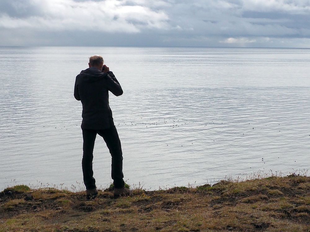
The trail is about 2.5 kilometers (1.5 miles) each way, and the first part is paved with a plastic grid which, with a little effort, should be wheelchair accessible. After that the trail is too rough.
Arnarstapi-Hellnar trail: Open all the time. No fee.
Days 17-21: Back to Reykjavik
Accommodation for 4 nights: Reykjavik
Book accommodations in Reykjavik using the map below:
If you are planning to visit some of the sights outside of Reykjavik, choose your accommodation’s location based on what sights you want to visit. Reykjavik is very spread out.
On Day 17, head back to Reykjavik. On the way, stop at the Settlement Center.
The Settlement Center
The Settlement Center has two different exhibitions: one historical, the other more literary. The first tells the historical story of how Iceland was settled, and the second tells a story from one of the Icelandic Sagas. The Icelandic Sagas were written in the 13th-14th century about events from the 9th-11th centuries. They purport to tell the stories of the first settler families, so they’re based in history, if not always completely accurate.
An audio tour narrated us through both exhibitions. There are no historical artifacts on show; if you want to see real items from the settlement of Iceland, you’ll have to go to the National Museum in Reykjavik.
Instead, we moved through a series of small spaces, dramatically lit, illustrating aspects of each story. We saw maps, drawing, photographs, videos, life-size or tiny figurines, and so forth, all contributing to helping us visualize the history / story. It was surprisingly well done.
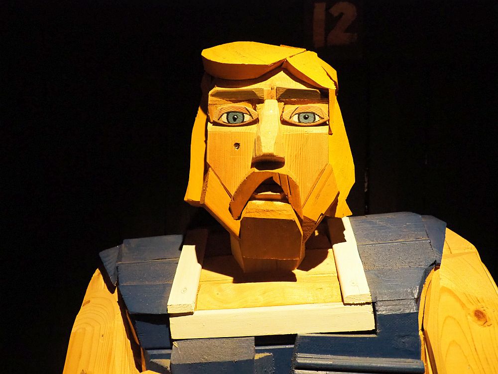
Iceland was first settled in the 9th century, and the settlement exhibition starts with explaining the routes that the Vikings took, not just to Iceland but all over the north, including Greenland and North America. It goes on to trace the settlement of Iceland up to the establishment of their parliament in 930 AD.
Given my love of history, I was less interested in the saga section, which focuses on just one of the sagas: Egil’s Saga. Egil was the son of one of the first Viking arrivals, who settled in this part of Iceland. The saga tells about his life and, like any such story, clearly strays at times from historical truth. Nevertheless, the artistry of the exhibition here is impressive: figures made by different artists illustrate each part of the saga as visitors are led through the rooms, listening to the audio telling the story.
The Settlement Center: Brakarbraut 13-15, Borgarnes. Open daily 10:00-16:00. Admission: 3,700 ISK; children 6-12 1,200 ISK. Includes audio tour. Website.
For the rest of your days in Reykjavik, visit more of the sights I listed in Reykjavik above for Day 1 (Jump to Day 1) and/or any of the sights you missed from Days 2-4 (Jump to Days 2-4).
There are also a couple more sights further out on the peninsula where Reykjavik is located:
The Blue Lagoon
After we’d visited so many thermal pools on our Ring Road trip, we decided we just had to see the most famous of Iceland’s thermal baths: the Blue Lagoon. You can read all about it in my article about thermal pools in Iceland.
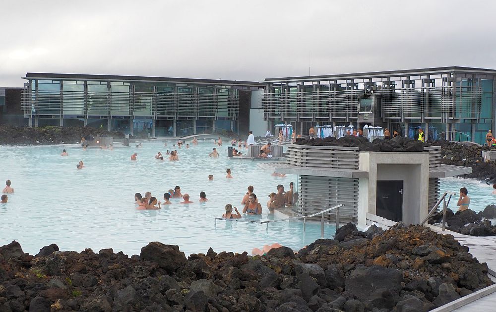
Blue Lagoon: About 50 minutes from Reykjavik, 15 minutes from the airport. Take route 41 to 43 and follow the signs. Open daily all year: August 21-May 31 8:00-22:00; June 1-August 20 7:00-midnight. Admission: Comfort level starts at €82, Premium at €102 and Signature at €126. Children 2-11 2,000 ISK. Children under 2 not admitted. Children 2-8 must wear floaties, which are provided for free. The Blue Lagoon books up, so reserve your date and time in advance! Tickets.
Reykjanes Lighthouse
If you have time before or after you enjoy the Blue Lagoon, you can drive out to the tip of the peninsula to see Reykjanes Lighthouse, Iceland’s oldest lighthouse. Rising from the tip of a hill, it makes quite the dramatic sight. Some impressive rock formations are nearby along the coast.
Reykjanes Lighthouse: From the Blue Lagoon, follow Route 43 towards Grindavik and take a right on Route 425 just before the town of Grindavik. Open all the time. No fee.
Day 21: Flight home
Three weeks was, in our view, a perfect length of time to feel like we’d seen Iceland. By driving the ring road, we didn’t see much of the interior. However, the fact is that most of the things we wanted to see were along the coasts or not very far inland.
Don’t forget to download the more portable version of this 3-week Iceland itinerary! It is much more compact – just the facts! Use the form below:
Map of our 3-week Iceland itinerary
Everything mentioned above is on this map. Use it to plan your choices. For a 3-week Iceland itinerary or a shorter one, this map should help.
Whether you use this itinerary or the downloadable one either in its entirety or in part, do let me know how it goes. I’d also love to hear if there are more sights I should include! Leave a comment below!
My travel recommendations
Planning travel
- Skyscanner is where I always start my flight searches.
- Booking.com is the company I use most for finding accommodations. If you prefer, Expedia offers more or less the same.
- Discover Cars offers an easy way to compare prices from all of the major car-rental companies in one place.
- Use Viator or GetYourGuide to find walking tours, day tours, airport pickups, city cards, tickets and whatever else you need at your destination.
- Bookmundi is great when you’re looking for a longer tour of a few days to a few weeks, private or with a group, pretty much anywhere in the world. Lots of different tour companies list their tours here, so you can comparison shop.
- GetTransfer is the place to book your airport-to-hotel transfers (and vice-versa). It’s so reassuring to have this all set up and paid for ahead of time, rather than having to make decisions after a long, tiring flight!
- Buy a GoCity Pass when you’re planning to do a lot of sightseeing on a city trip. It can save you a lot on admissions to museums and other attractions in big cities like New York and Amsterdam.
- Ferryhopper is a convenient way to book ferries ahead of time. They cover ferry bookings in 33 different countries at last count.
- I’ve become an affiliate for VisitorsCoverage travel insurance, mostly because you should ALWAYS have travel insurance when you travel! You may be young and healthy and never get sick, but the fact is, sh*t happens, and it’s worse if you don’t have insurance!
Other travel-related items
- It’s really awkward to have to rely on WIFI when you travel overseas. I’ve tried several e-sim cards, and GigSky’s e-sim was the one that was easiest to activate and use. You buy it through their app and activate it when you need it. Use the code RACHEL10 to get a 10% discount!
- Another option I just recently tried for the first time is a portable wifi modem by WifiCandy. It supports up to 8 devices and you just carry it along in your pocket or bag! If you’re traveling with a family or group, it might end up cheaper to use than an e-sim. Use the code RACHELSRUMINATIONS for a 10% discount.
- I’m a fan of SCOTTeVEST’s jackets and vests because when I wear one, I don’t have to carry a handbag. I feel like all my stuff is safer when I travel because it’s in inside pockets close to my body.
- I use ExpressVPN on my phone and laptop when I travel. It keeps me safe from hackers when I use public or hotel wifi.
Rachel Heller is a writer living in Groningen, the Netherlands. She is the owner and primary author of this website, Rachel’s Ruminations, a travel blog focused on independent travel with an emphasis on cultural and historical sites/sights. Read more here about her and about this website. All photos in her articles are her own, unless otherwise specified. Rachel also owns and operates a website about World Heritage travel.
Great post and pictures to motivate us for including Iceland on our next trip to Europe – hopefully in the fall!.
Our son who had toured Iceland twice told us much about it as well. He also confirmed that English is widely spoken.
We always learn and practice, however, at least basic greetings and polite phrases when visiting any country whose language we don’t speak!
Fantastic” Do you think it’s a good trip to do with kids? 4 and 7?
That would depend on your kids. It’s a lot of driving – how are they with sitting in the car? If that wouldn’t work for them, I’d suggest just driving the golden circle and staying in each place for longer.